IMAGE
ICC Territory and Boundaries Item Info
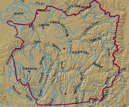
- Title:
- ICC Territory and Boundaries
- Description:
- ICC Territory and Boundaries, of some 13 million acres, marking the aboriginal use area as described in the treaties (affirmed by the Indian Claims Commission in 1967). The ICC map, established in 1967 as described in Docket No. 175 18 1,11. The boundary was mapped by the Bureau of Indian Affairs onto 1:24,000 scale U.S. Geological Survey map sheets and digitized with the registration residual mean squares error <0.03 inches. Map error at 1:800,000 scale is approximatley 200 feet or 0.04 miles.
Source
- Preferred Citation:
- "ICC Territory and Boundaries", Nimíipuu L3, Center for Digital Inquiry and Learning (CDIL)
- Reference Link:
- https://cdil.lib.uidaho.edu/nimiipuu-l3/items/nimiipuu-l3-029.html