Humans
from Sedimentation: An Archive of Glen Canyon
HUMANS
Inscriptions
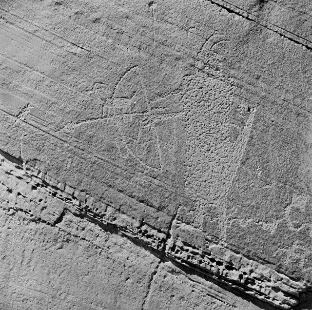
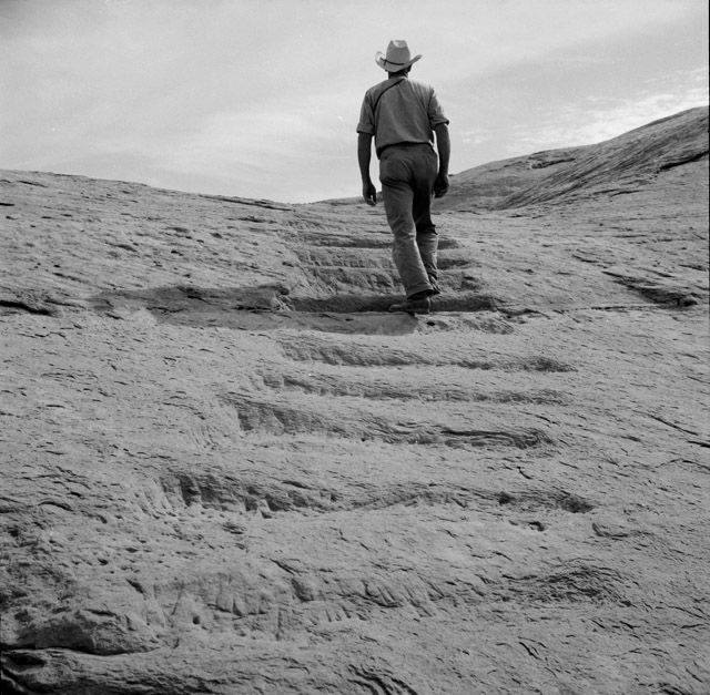
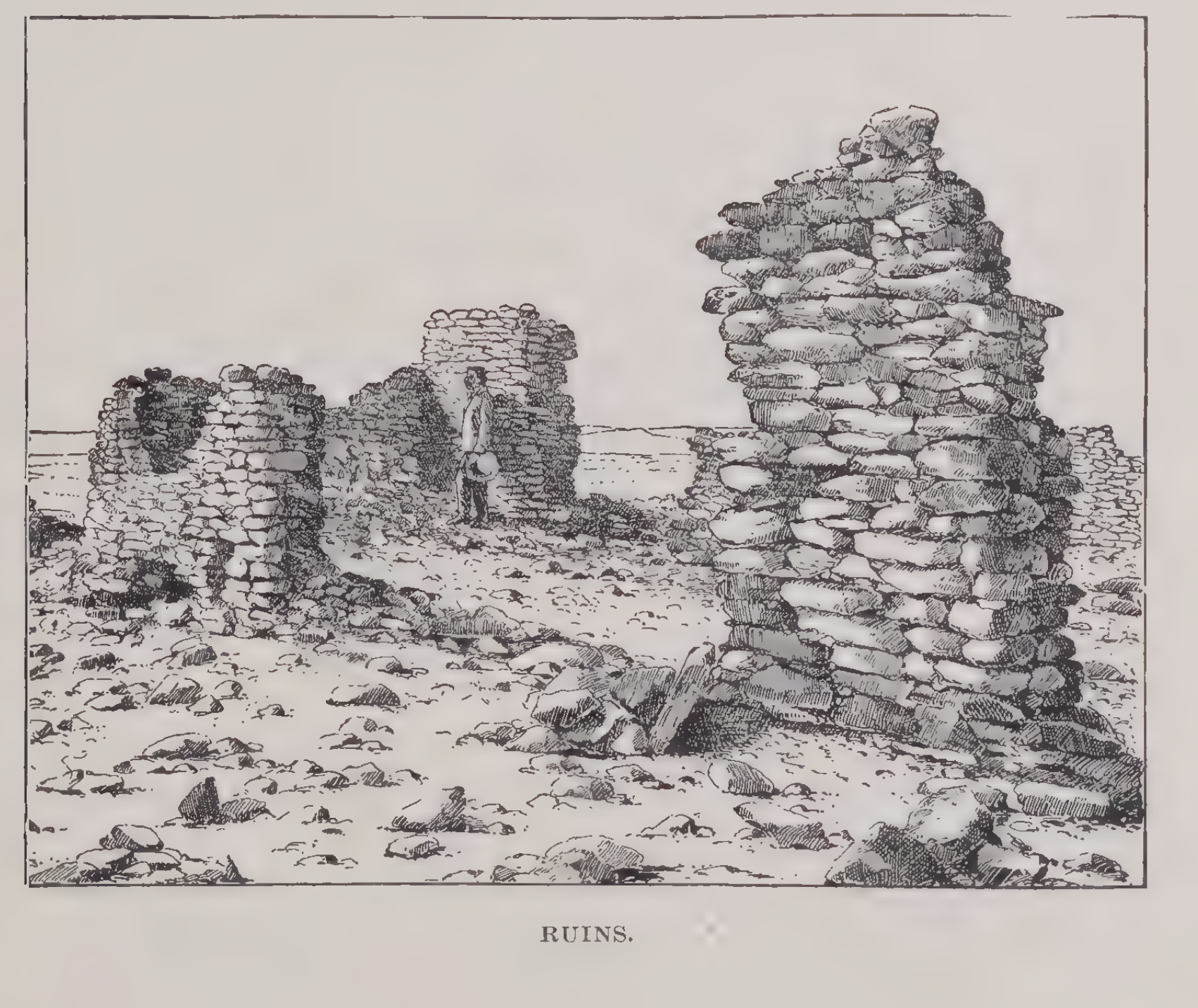
SCRAWLED ACROSS GLEN Canyon’s rock faces are the tracks and tracings of human life. Some of these markings are inadvertent, the scars left behind as people moved through and settled in the Canyon. Chinked steps, gouged footholds, and dynamite-blasted trails reveal where Paiute hunters, Diné sheepherders, Spanish Conquistadors, Mormon pioneers, and uranium miners sought access to – or passageway through – the canyon’s enclaves. Dugout caves, adobe dwellings, stone granaries, irrigation canals, and the borings of loom holes locate where Pueblo weavers, Hopi Farmers, and gold prospectors made their homes.
Other markings are intentional, as if those humans who engraved petroglyph tapestries and carved out their names wanted to ensure their existence was remembered by the people of the future.
All of these markings, inadvertent or intentional, assert a claim over Glen Canyon.
Every trail, etching, and boring is a result of a human who felt that the land was theirs to alter, that the rocks and mud were theirs for home-building, that the canyons were theirs to blow open, or that the sandstone was theirs to inscribe.
For political ecologist Laura Ogden, such processes, in which an actor – human or not – reworks the elements of the earth in order to profess or make possible their belonging are forms of territorial inscription.
“Birds claim territory through song;” she writes, “fiddler crabs dig burrows; ocean life glows with bioluminescence; beavers build lodges and dams. The suburbs are a nested architecture of inscription practices, from gated entrances to backyard privacy fences. These practices of territorial inscription leave their mark on the world, though sometimes the mark is just a shimmer.” 1
Glen Canyon’s inscriptions trace out a kind of territorial map, overlapping with various kinds of claims.
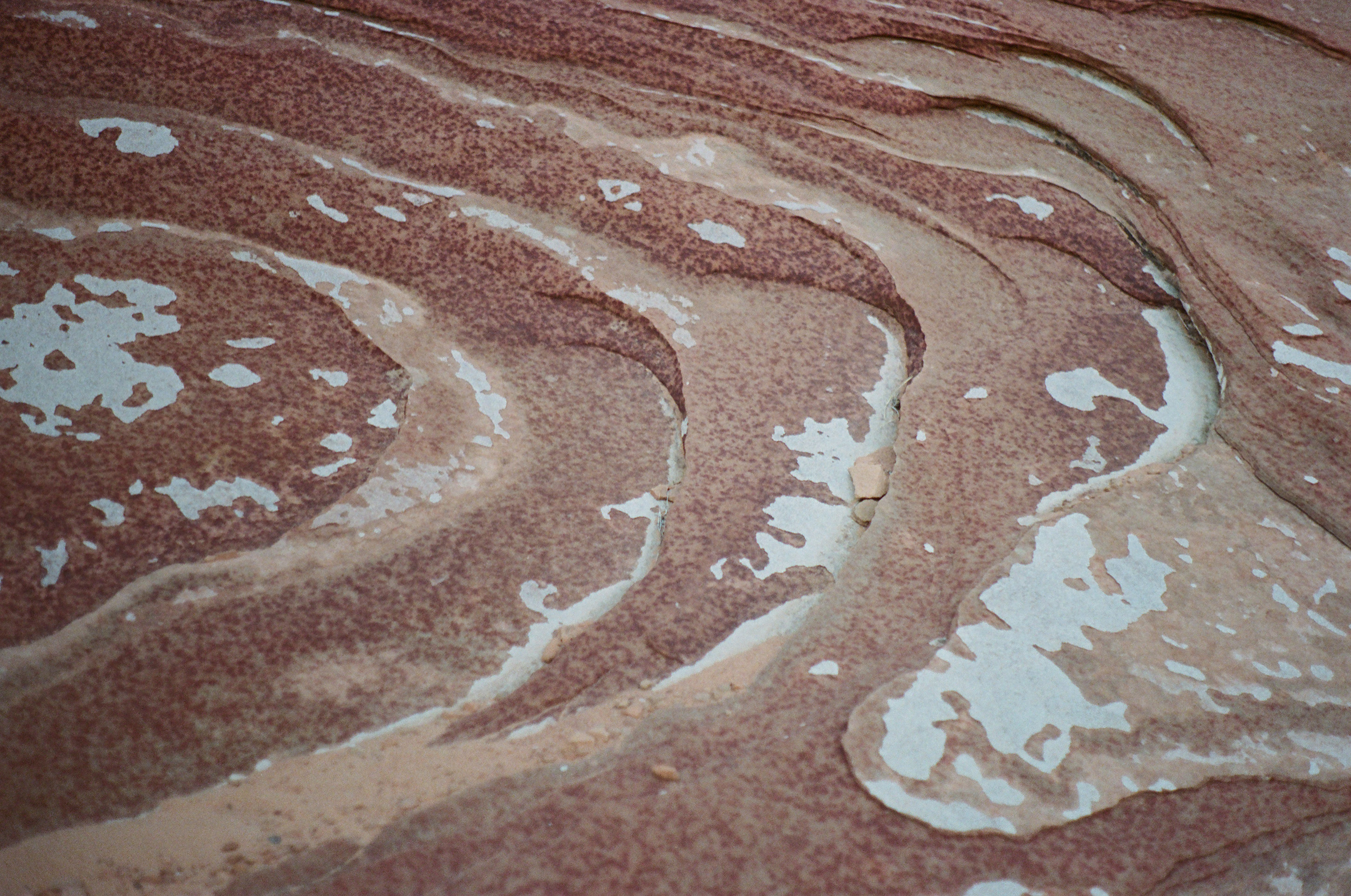
This map is not flat, and its territories do not sit cleanly beside one another (as few territories do). This is a vertical and lively cartography; more like a palimpsest in which various inscriptions layer and touch, transform and efface one another through time. This is a map whose material is always in the process of erosion, recirculation, and reconfiguration as competing actors draw and redraw territory with the substrate of their predecessors.
For instance: microbes fester in sediment beds that, before the dam, were thickly threaded with willow roots. Mormon emigrants deconstruct Puebloan cliff dwellings as they pillage stones for their own homes. A creekside beach once packed with antelope tracks is obliterated – wiped entirely off the map – when its sand is harvested to fill the concrete walls of the Glen Canyon Dam.
Yet even in those places most ravaged by territorial erasures and remappings, the traces of past inscriptions can linger, though they are often faint and fragmented (willow branches fossilize in lake beds; pot sherds are interred beneath the soil of a garden; antelope are memorialized by the name of a canyon). Faint as they might be, these traces scrawl out a ghostly map, embossed with layered claims.
Subsumation
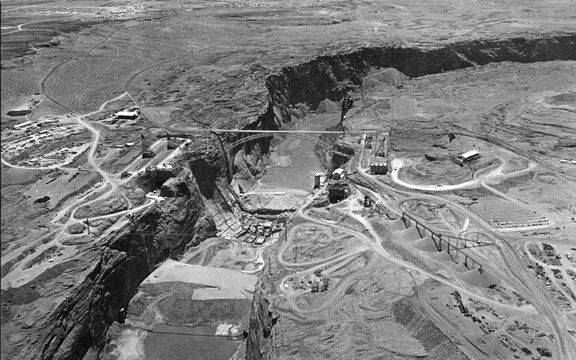
WHEN THE GLEN Canyon Dam was completed in 1963, the United States declared – in the dam’s 700-foot tall concrete walls and in the reservoir it sent spreading out over the land – that the Canyon and its flooded tributaries were theirs. As Lake Powell bloated higher and swelled further than the river had ever reached, its waters engulfed thousands of Indigenous petroglyphs, dwellings, and trails. It bleached away, too, the microbial films that once draped the Canyon’s walls, and it drowned hordes of lizards, scorpions, and snakes and the makings and markings of their lives. The lake razed swaths of coyote willow, columbines, and cottonwoods which bloomed along the river’s edge, and it hid the once volatile Colorado River beneath its glossy surface. Lake Powell covered, too, the remains of Glen Canyon’s early settlement efforts: it swallowed the physical residues of mining operations, the etchings made by the canyon’s white explorers, and the homesteads of its first settlers.
Together, the dam and the lake visually and symbolically insist upon complete colonial territorialization, and they serve to erase the archive of the lives that came before, removing evidence of a different past, of other claims to the land.
That the dam was first and foremost a claim-making project is literally inscribed in the name of the agency that built it. The Bureau of Reclamation named itself after their mission to “reclaim” the lands of the West for settler use.
The Bureau of Reclamation, and the dams it built, work to transform a landscape brimming with other existences into a terra nullius, a blank space on the map ready to be developed. This kind of subsumation props up western notions of linear progress and unidirectional time, and it reifies the belief that the present can be laid cleanly over the past like the next layer of strata.
But neither the earth nor history are quite so stratigraphic. Instead, particulates of the past are constantly eroding and resurfacing into the present and the future. In Glen Canyon, reemergence and recirculation are not metaphors. Glen Canyon’s inscriptions cut through time, bringing people of different temporalities into contact and interaction with one another.

Presence of Absence
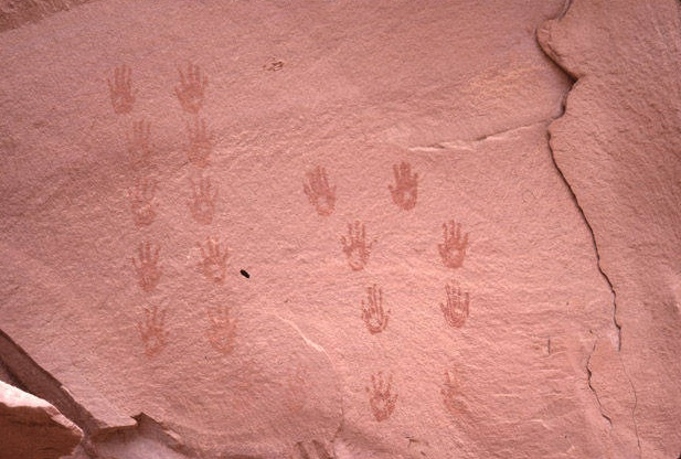
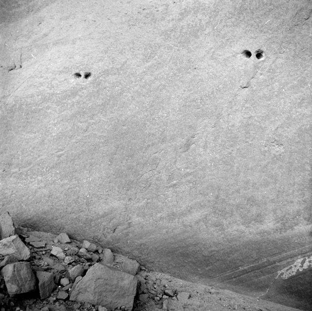
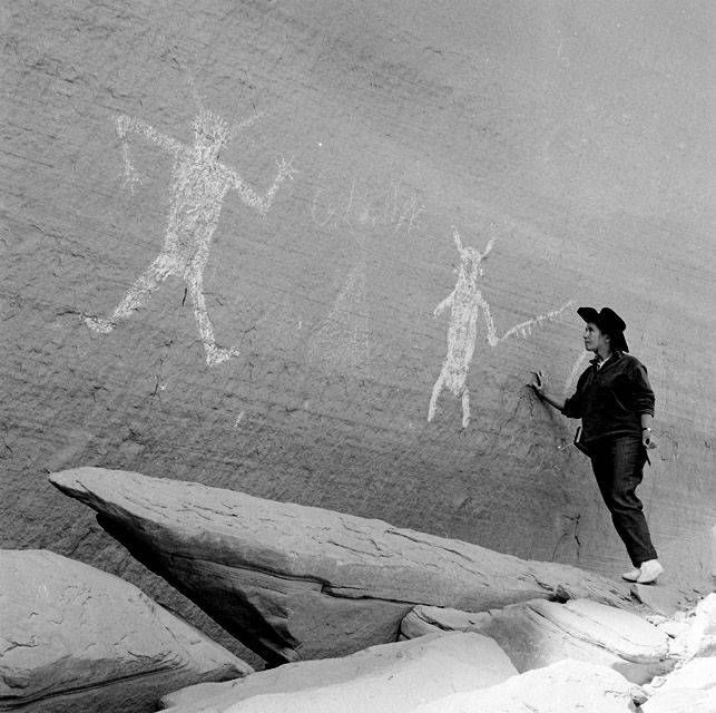
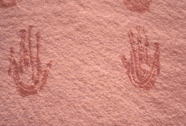
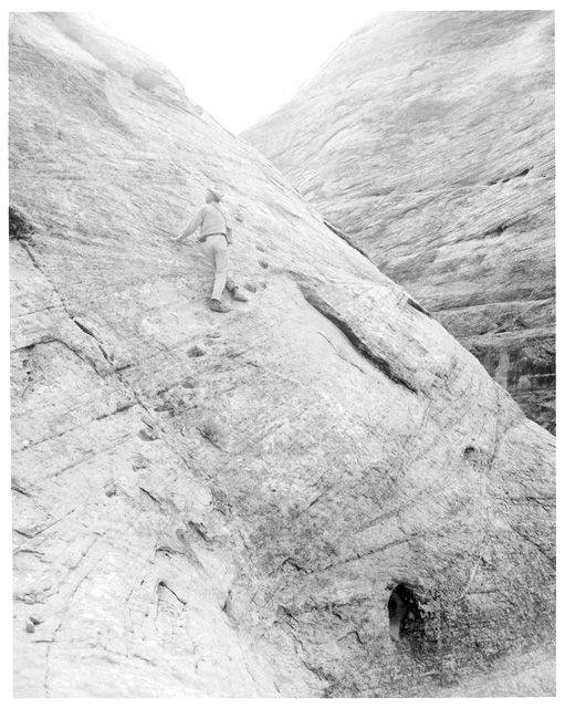
SOMEONE GATHERS UP rust-colored rocks and heaps them into a shallow stone bowl. With another, stronger stone, they pulverize the rusted rocks into dust and stir in water, or their own spit, or animal fat or blood, until the dust becomes a red and gluey paste. They dip each of their hands in the paste and press them splayed against a sandstone wall. Their companions follow suit, leaving ten pairs of dark handprints reaching up Glen Canyon’s sides.
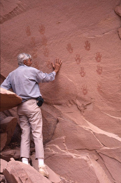
Long after the people move on, their handprints remain, registering their existence and this moment of contact with Glen Canyon, this blending of stone and water, spit, or animal. As other people from different times and places pass by the wall, some place their own hands over the prints, as Tad Nichols does here. For a moment, the people of the past and the present draw together, sharing the same gesture in the same place.
Handprints like these are sometimes called dermatoglyphs, which Laura Ogden translates to mean “traces of existence.” They carry, she writes, “the past and being-in-the world forcibly into the present. In doing so, they touch us.” 2
Something is communicated in this touching: a recognition of presence and precedent, perhaps. “We were here, just as you are now” the handprints seem to say. But there is something ghostly about the prints too; the absence of other bodies feels conspicuous – almost tangible – in the empty space around Tad.
For Jacques Derrida, traces are inherently spectral in that they disclose the “absence of presence” by drawing attention to what was once there, but is no longer.3
The handprints, then, emphasize the absence of their makers, but they make visible other kinds of absences, too: as I attempt to write about the prints, I am faced again and again with the incompleteness of their record, and the incompleteness of my own knowledge. Enclosed between the prints’ slim revelations are seas of unknowns: the prints testify to another’s presence, and their chemical signatures offer hints about the processes by which they were made, but they do not tell us much more than that. We cannot know who these people were, or discern their names, or their relation to one another, or know their dreams, sorrows, or joys. Without this information, I cannot apprehend the makers in all their human complexities, and any attempt to fill such gaps would almost certainly efface the handprinters as they were, and instead replace them with some distorted version of my own.
I am reminded here that as I read the traces of the past, I must be careful not to reduce the silences – and all the possibilities they contain – in an attempt to write a complete story. It is enough to accept the handprinters’ declaration of existence, and it is enough to be touched by their presence.
It strikes me, then, that the handprints do not mark an absence of presence so much as a presence of absence. I do not mean the kind of absence that denotes nonexistence, nonparticipation, or a complete lack of being in and bearing on the moment. Instead, the handprints preserve a lingering existence; they carry their makers into an ongoing participation in the world that exceeds their physical absence. As Tad touches the prints, they touch him too, altering his interactions with the canyon.
But just as the past informs and transforms the unfoldings of the present, so can the present disfigure the traces of the past. When Tad pulls his hand from the wall, he will lift flecks of paint off the prints, wiping away, forever, a bit of history. If this gesture is repeated enough times, the handprints will be erased, and will no longer communicate to visitors about the people who came before.
The remains we encounter – or ourselves leave behind – allow us to connect with humans across otherwise unreachable spans of time, drawing us into conversation and relation with one another. When we alter these remains, we rupture the possibility for the people of the future to commune with the people of the past. It matters, then, how we touch such traces.
Palimpsests
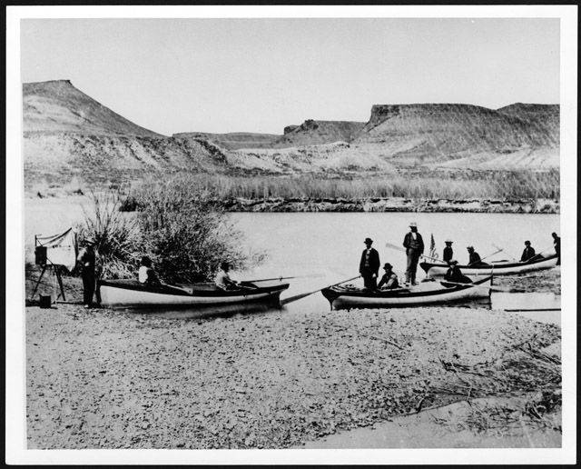
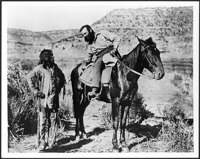
ONE DAY AFTER the completion of the Transcontinental Railroad, ten men disembarked from a Union Pacific Train at Green River Station, Wyoming. They had with them four wooden boats, packed with compasses, thermometers, guns, ammunition, coffee, flour, bacon, and beans – all paid for by the U.S. Army. Thirteen days later, on May 24th, 1869, the men and their boats pushed off from the banks of the Green River and headed downstream, towards the Colorado. They would paddle nearly one thousand miles over the course of the next three months, lose one of their boats and a third of their food, and three of the men would die.
Their leader was John Wesley Powell, a one-armed Civil war Veteran, geologist, ethnographer, and botanist, and their purpose was to survey the length of the Colorado and Green Rivers. While his men rowed, Powell assessed the land’s potential for settlement and agriculture, and he filled in what had been previously considered a “blank spot” on the map of the United States with data on the region’s topography, climate, botanical makeup, water resources, and Indigenous cultures.
The maps and reports that Powell produced on this expedition (and another one like it two years later) would greatly shape the course of Western development. Powell identified that survival in the West was more contingent on access to water (which was scarce) than land (which was plenty); a direct inversion of the conditions that governed settlement in the East. Eastern settlers were land hungry, but had taken water for granted, and until Powell’s expeditions, expansionists had not considered that in order to move westward, they would either have to reconfigure their lifestyles – or reconfigure the land.
Powell cautioned Congress in 1890 that life would have to mold itself around the West’s sparse waterways, and he proposed that state lines be drawn not according to “the logic of the grid,” but instead along watershed boundaries. Each state, Powell suggested, would oversee and implement public irrigation infrastructure, and water would be cooperatively managed by basin residents.
At first, Powell’s heedings were wholly rejected. Such a collective approach to resource management clashed too strongly with American desires for unfettered growth, rapid expansion, and individual freedom. What’s more, lawmakers, like many Americans, believed that as emigrants surged westward, “rain would follow the plow.”
But by 1902, Congress had come to accept that agrarian settlements in the West would fail (as many already had) without help from large-scale water management interventions – just as Powell had originally advised. Thus, the Bureau of Reclamation was born, a government agency which would go on to construct over 600 dams and drastically transfigure the landscapes and waterflows of the West.
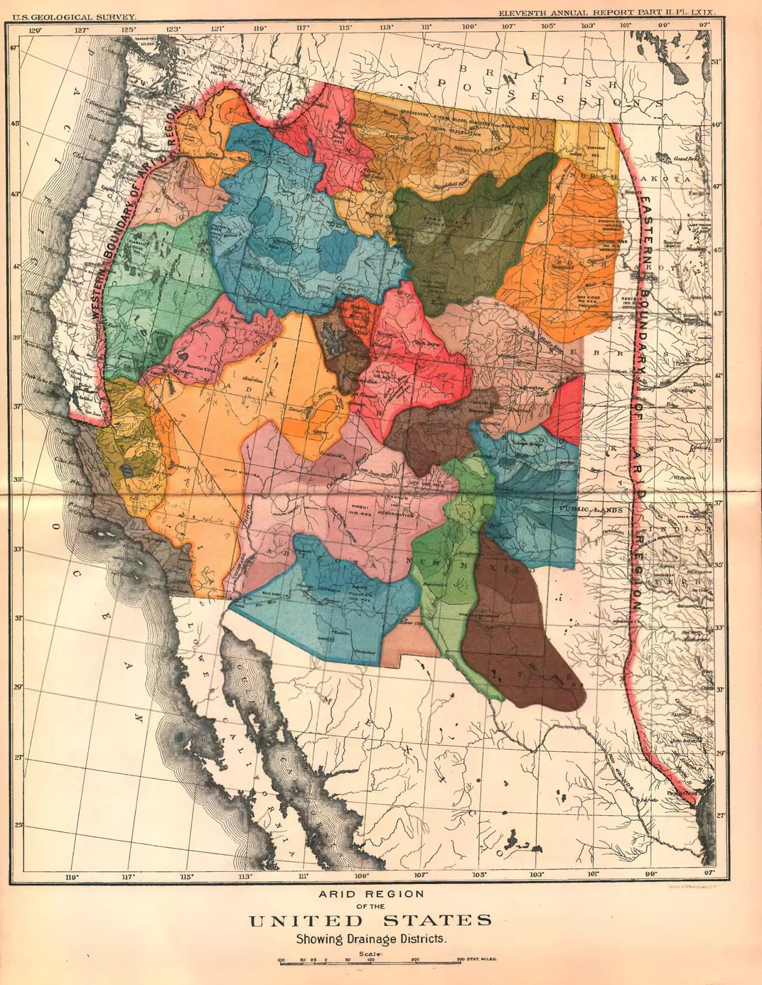
Before these projects could begin, or even be imagined, the American West had to first be carefully mapped, its water tallied, and its topography plotted. Land managers, engineers, and lawmakers needed to understand the contours of the land and the precise location of its resources in order to lay out plans to settle and develop it. Even if Powell’s dream of communal watershed governance was never to materialize, the data he collected on his expeditions nevertheless laid the groundwork for the Colorado River to be transformed into a tightly-regulated plumbing system, choked with dams and siphoning aqueducts.
Much of the data that Powell provided Congress was gleaned through traditional survey methods. He measured distances by triangulating his position in relation to the stars; he carefully tracked the river’s gradient with thrice-daily barometer readings; and his botanical observations – “luxuriant grasses” or “thorny cactus here and there”–helped him estimate regional rainfall patterns. 4
But Powell was an ethnologist as well as a botanist-geologist, and he knew that local Indigenous communities possessed “intimate knowledge of the landscape” that could help him understand how the region’s resources might best be harnessed for human use. Powell extracted a wealth of information from the Indigenous communities he encountered, and he was often explicit about these strategies. In the Grand Canyon, for example, Powell met a band of Shi’-vwit Paiutes, and told their chief that “I wish to learn about their cañons and mountains, and about themselves, to tell other men at home; and that I want to take pictures of everything, and show them to my friends.” 5
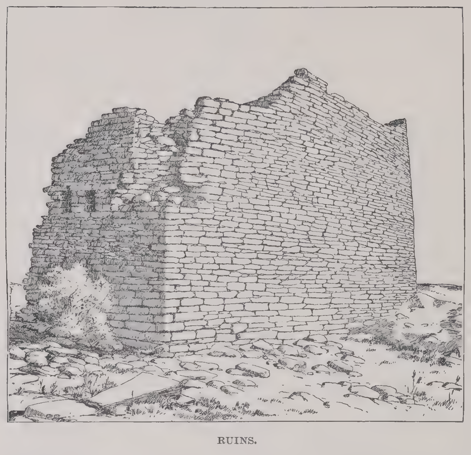
Powell also understood that the rock art, dwelling structures, and irrigation canals he encountered offered vital insight into how the land had been utilized in the past, and thus could be utilized in the future. His journals are full of archaeological descriptions. For example, upon finding a ruin at the foothills of the Vermillion cliffs (which rise above the lower portion of Glen Canyon), he wrote: “from extensive study of the ruins, it seems that everywhere tribal pueblos were built of considerable dimensions, usually to give shelter to several hundred people. Then the people cultivated the soil by irrigation, and had their gardens and little fields scattered at wide distances about the central pueblo, by little springs and streams and wherever they could control the water with little labor to bring it on the land.” 6 Irrigation, Powell concluded, “is necessary in this dry climate to successful farming.” 7
Powell was not the first or the last frontiersman to leverage Indigenous knowledge in order to determine a landscape’s potential for colonization. In fact, the practice of extracting knowledge only to dispossess and erase its producers was so central to the region’s colonial development, historian Erika Marie Bsumek filled an entire book chronicling repeated instances of this pattern. And as Bsumek notes, while settlers often pilfered information directly from Indigenous informants, they also frequently extracted insight from whatever material traces they encountered.
“In many cases,” Bsumek writes, “white settlers, surveyors, and engineers first located Indigenous irrigation ditches in order to find the most promising sites on which to build their own communities.” 8 The value of such markings was so significant, one Mormon missionary proclaimed the Colorado Plateau a viable site to settle because he “had evidence that this land has been densley [sic] populated.” 9
Neither Powell, nor the Mormons, nor any white settler thereafter seemed to interpret “evidence” of Indigenous existence as an assertion that this was a territory that had long ago been claimed – whose claims were inscribed on the land itself, and which was still “densely populated” by hundreds of thousands of Native people. Instead, they viewed such evidence as a repository of useful information which could be harnessed to further their own aims.
Inscriptive practices can declare territorial claims, but they can also be appropriated for remapping by those in pursuit of endless expansion.
Such a pattern is by no means unprecedented: the pillaging of others’ knowledge without the consent, inclusion, and respect of those who produced it is often the mechanism by which colonial cultures seek their ascendancy. And as Bsumek reminds us, such an ascendancy relies not only on the use of stolen knowledge, but also on the erasure of its producers. It is only through this process of simultaneous extraction and erasure that colonial agents can maintain the narratives of supremacy upon which their projects depend.
Indeed, the re-settlement of the Colorado River Basin was predicated on first clearing Indigenous people from the land, and then removing any evidence of their belonging. At the same time as Mormon missionaries and government agencies launched violent removal campaigns – such as the 1864 Long Walk, which forcibly relocated 8,000 Navajo men, women, and children from their homelands to an internment camp at Fort Sumner, New Mexico – settlers also worked to expunge physical traces of Indigenous existence, or overlay them with their own inscriptions.
As Powell noted, Mormons often used stones taken from Native dwellings to build their own homes, and as they laid irrigation ditches over those already there, Mormon settlers simultaneously averred their own claims over the land while eradicating any physical indication that the land had previously belonged to someone else. 10
In order to justify these encroachments, colonizers frequently invoked stadial theories of evolution, which imagined that newer, more advanced civilizations will naturally succeed and subsume those older and less advanced, like the accrual of new strata on top of old. However, the reality that settler infrastructures were established not on top of prior cultures, but using their materials undercuts this kind of stratigraphic logic; Mormon settlements were made possible because they were built with the stuff of the past, not on top of it. 11
Practices of cultural superpositions not only assuage the settler consciousness and affirm their belonging, they also reify false narratives that Euroamerican settlers were the first to successfully develop the land for permanent habitation. But as the region’s irrigation canals, dwellings, granaries, water storage tanks, and hunting trails attest, Indigenous cultures had long ago figured out how to adapt the land – and their own subsistence strategies – to support long-term survival and flourishing.
However, when Powell came across these “ruins”, many of which were no longer in use, he concluded that the region’s contemporary Indigenous populations must be less “‘civilized’ than their ancestors,” and decided that “Indigenous cultures belonged to the past, not the present.” 12 Powell read, in other words, the absence of Indigenous presence within Glen Canyon to indicate cultural obsolescence, a narrative which legitimized Euroamerican encroachment. But of course, physical residues alone rarely tell a complete story, and attempting to fill in the gaps – as Powell did – risks filling them with mistruths and misunderstandings.
At the time of Powell’s expedition, there were dozens of Indigenous groups living on Glen Canyon’s shoulders, many of whom were descended from those people who had built the gardens and dwellings that Powell encountered. Their ancestors, the Ancestral Puebloans, had not disappeared; they had purposefully migrated out of the Canyon in order to survive an episode of drought – a common phenomena in the Southwest’s variable climate.
The absence of permanent inhabitants in the Canyon at the time of Powell’s surveys, then, was not a result of cultural regression (as Powell claimed), but is rather a testimony to the Puebloans’ deep knowledge of the region’s long-term climatic patterns as well as their ability to successfully adapt to a shifting environment. Cyclical migration is a common adaptive practice for cultures living in changeable climates, and Indigenous communities have persisted on the Colorado Plateau over thousands and thousands of years precisely because they have calibrated where and how they lived with the ebbs and flows of the region’s water. Teresa Pasqual, director of the Acoma’s Historic Preservation Office, richly captures the migratory patterns of her Puebloan ancestors:
“Those movements weren’t linear. They weren’t from point A to point B. They happened to move and almost move like waves of—of the ocean upon the beach: in and out, back and forth. They moved across the landscape, depending on what resources were available to them.” Pasqual continues to emphasize that Westerners have difficulty grasping this kind of lifestyle because “from a Western perspective, almost anything that we do, is very linear. There’s a beginning and there’s an end… But for our Pueblo communities, and I would dare say for almost all of our indigenous communities, that is not the way that we approach things…Time for us as Pueblo people can be present, it can be the future, it can be the past, and it can be all of those things at the very same time.” 13
Time, as Pasqual indicates, does not necessarily proceed along stratigraphic lines; time can cycle and pulse, mixing the past, present, and future into its flows. It follows, then, that survival is not always achieved through sedentary accumulation and unidirectional progress; oftentimes, survival requires mobility and responsiveness as the earth cycles through its rhythms, which themselves are rarely linear.
However, these rhythms and pulses tend to exceed the span of a single lifetime – let alone the span of Powell’s two expeditions – and Indigenous knowledge about climatic fluctuations and how to adapt to them is often accumulated over thousands of generations. Powell, an easterner descended from Europeans, had no such generational insight, and he therefore had little context for understanding why the ruins he encountered might be vacant. In his attempts to fill these gaps, Powell inserted a false – and racialized – narrative about civilizational decline, and he blinded himself to the sea of other stories that the ruins, the landscape, and its people contained.
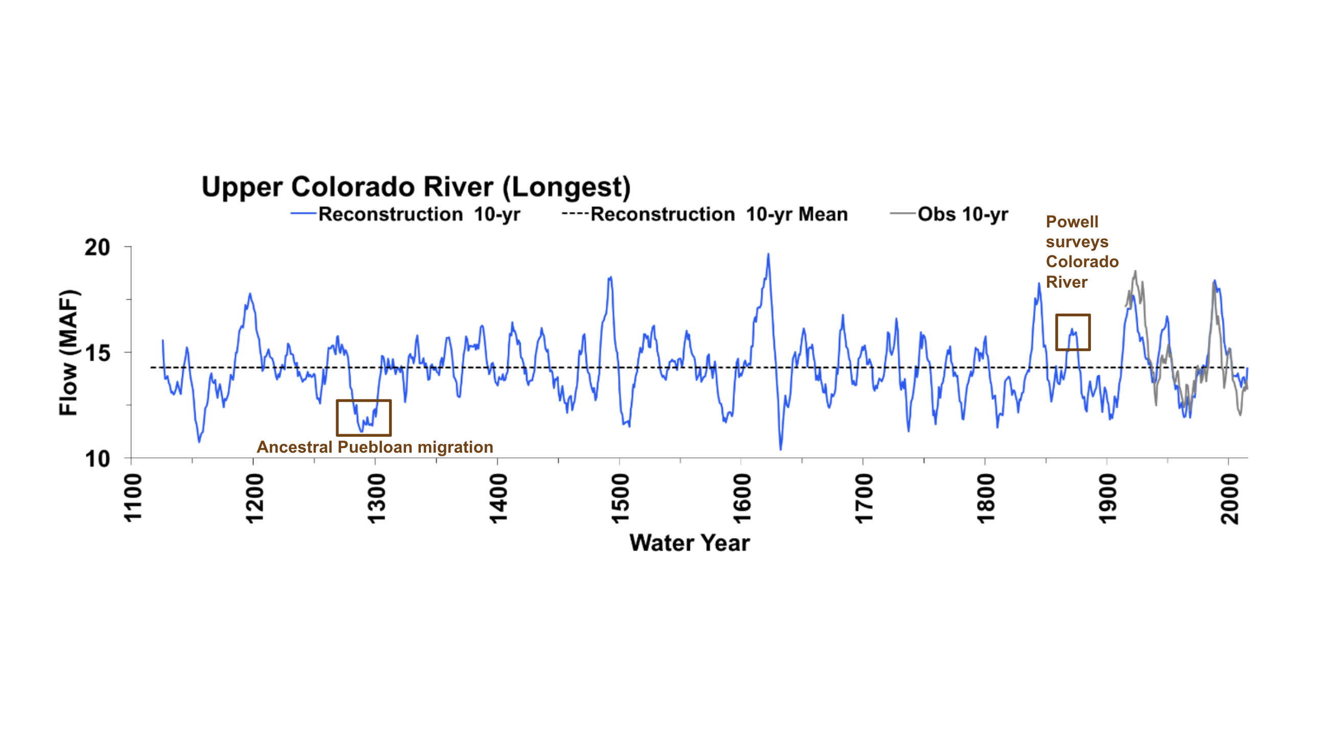
Scientists have since figured out that tree rings store a yearly catalog of their environment’s climatic history, and as the trees attest, both of Powell’s expeditions took place during an unusually wet period. Reconstructive modeling indicates that in the year of Powell’s first expedition, the Colorado River saw water flows around 20 million acre-feet, about 30% more than the long-term average. Thus, at the time of Powell’s expedition, there was enough water in the basin to indicate that sedentary, agriculture-based settlement was possible, as long as this water was carefully managed and partitioned. 14
What’s more, the only part of Powell’s message that Congress received – or at least decided to heed – was the part about the possibility of development. Powell’s brightly splotched maps, black and white sketches, and written reports apparently did not fully convey the realities of the southwestern climate. And so, from their seats in the humid, verdant East, legislators went ahead and transposed temperate plans for living onto Powell’s map of the West.
Since then, the climate of the Southwest has cycled again into drought. Fueled by warming global temperatures, the Colorado River is facing its driest spell in 1,200 years – drier, even, than the drought which drove the Puebloans to move out of the river’s canyons. 40 million people now live across the river basin, most of whom depend on the river to provide them with water and electricity, and almost none of whom are prepared to pick up move elsewhere if and when the water gets too low. And so the chain of misreadings that began in 1869 – first Powell’s misreading of the landscape, and then Congress’ misreading of his reports – will continue to bear heavily on the people of the present.
I am not sure whether development West would have unfolded along even slightly different lines if those Eastern congressmen had seen, with their own eyes, what Powell saw: had they climbed up into those Puebloan ruins, or listened more attentively to the people who already lived there; had they squeezed through canyons scoured by spring floods and slung with high-flung debris; had they paddled across that thin and muddy river which contains so much of the West’s water; had they mired their boats in its shifting sandbanks. Would they have better understood that this is a territory already claimed? Would they have seen that this is a land of little – but sometimes violent – water flows? Would they have realized that long-term survival in a place of such constant flux required mobility and adaptation, not great immovable infrastructures?
It would be naive, of course, to argue that prudent legislation comes all the way down to making decisions about place in place. As I have gestured to here, the engine of colonization was not fueled entirely by optimistic ignorance, but also by a voracious hunger for “incessant expansion” combined with stadial logics.
Americans today, however, are living with the legacies of those decisions, and have inherited the dual responsibility of modifying cultural practices and infrastructures in order to adapt to a changing climate while also remediating harms already inflicted by these practices. These responsibilities, I believe, are mutually inclusive: both will involve reckoning honestly with the mistakes, misreadings, inattentions of the past, and enacting modes of living that devote closer attention and care towards the people, species, and landscapes we share the planet with.
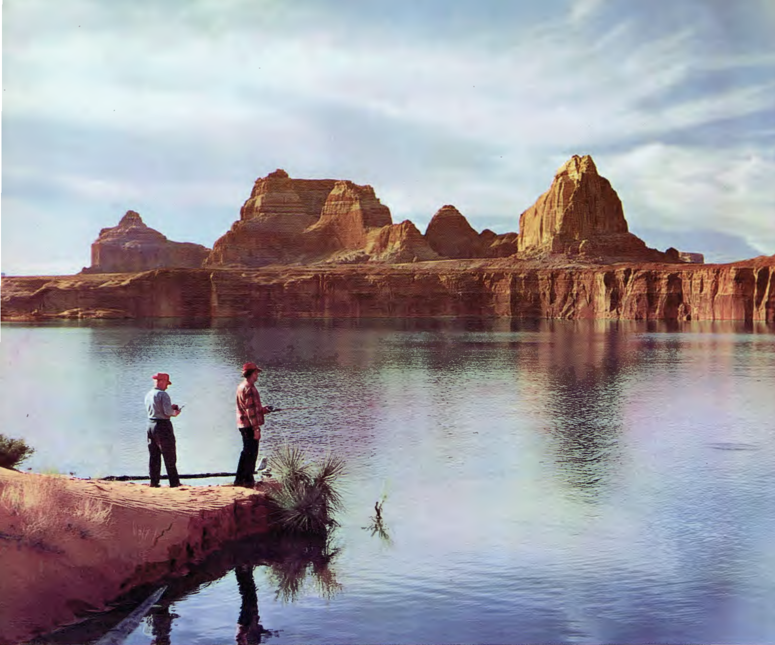
It is difficult to enact a more attuned, inclusive, and just future, however, when the record of the past – and the traces of the people, biota, and landforms that composed it – is hidden from view. It is hard to believe, for example, that the Colorado Plateau is a land of precious water while standing at the edge of a deep and sprawling lake, even if that lake is slowly shrinking. And it is difficult, too, to sense the web of life, loss, failure, success, and resilience that composes the present when the markings of these lives lay beneath hundreds of feet of water.
But as the drought draws Lake Powell lower, Glen Canyon and its palimpsested inscriptions are resurfacing. This time, we must pay closer attention, and not rush to fill the gaps with our own stories.
Interior Landscapes
Western society – with its Cartesian dualisms, tendencies toward commodification and extraction, and global imperialism – has somewhat successfully abstracted the processes by which nature forges, and includes, culture. But for many other societies, place and culture are still intimately, inextricably twined.
As Silko shares, this is case for traditional Puebloan societes: Puebloan stories – which are critical modes of sharing knowledge and values – are almost always tethered to specific geographical features, though Silko notes that “it is impossible to determine which came first, the incident or the geographical feature that begs to be brought alive in a story.” 15
Silko illustrates the entanglements between landscape, story, and culture by recounting a family narrative: she tells of her sheepherding relatives who were killed when they strayed into the shadow of a high dark mesa, and thus could not see the Apache raiders lying in wait for them. Silko’s story at once brings alive the mesa, showing its critical role in determining the life and death of her relatives, and it also embeds the memory of her relatives within the mesa: “for as long as the mesa stands,” she says, “people within the family and clan will be reminded of the story.” And, her narrative affixes instructions about how to best navigate the mesa to the mesa itself. “Thus,” she emphasizes, “the continuity and accuracy” of Pueblo knowledge is “reinforced by the landscape.” 16
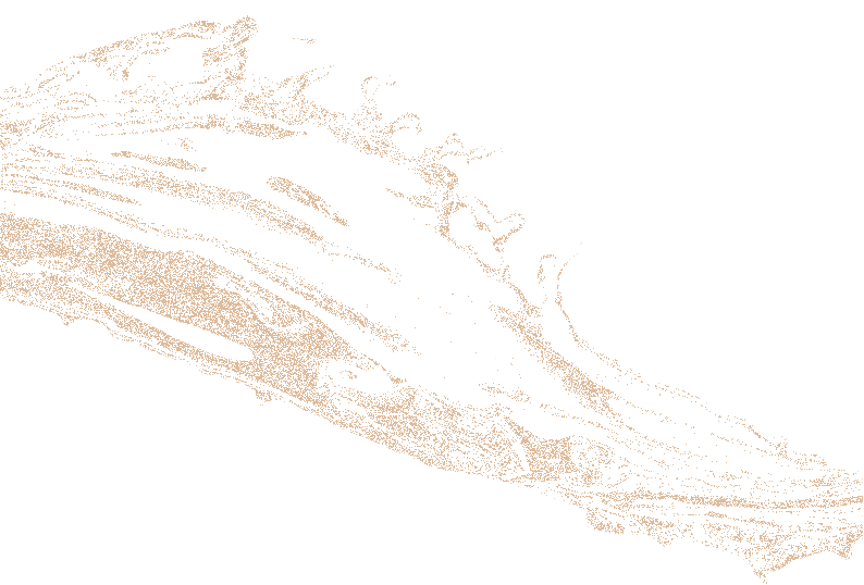
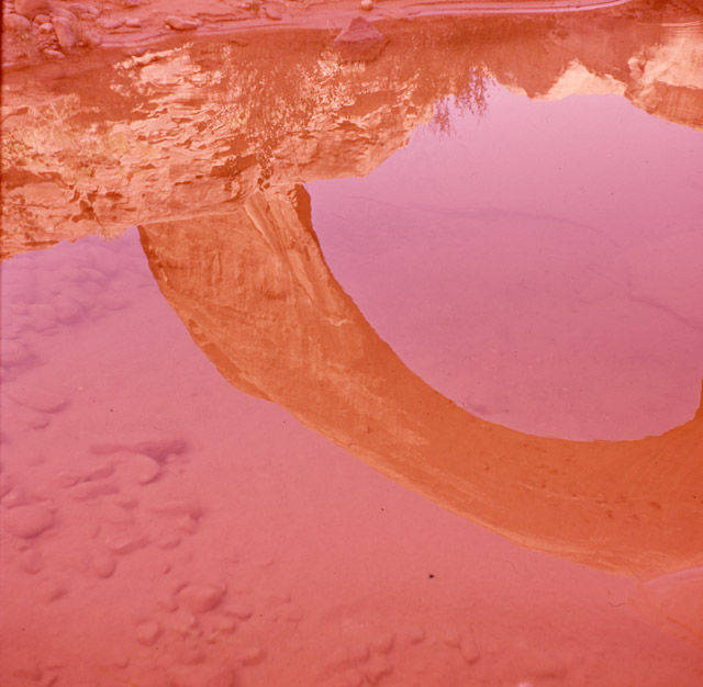
For the Diné, too, geographical features actively participate in cultural formation and survival. Tsé Naní’ áhiígíí, a rainbow-shaped rock bridge wedged between the walls of Bridge Canyon (one of Glen Canyon’s tributaries), has long oriented both spiritual and material life for Diné people. Stories about the origins of Tsé Naní’ áhiígíí abound, offering knowledge about proximal springs where people might draw water, about how to ask for rain in periods of drought, how to travel across the Plateau’s chasmal landscapes, and about the movements and unions of the Holy people. One account shares that the Holy people created Tsé Naní’ áhiígíí as a place of refuge in “the safest place they could imagine” – and when Kit Carson launched a violent removal campaign against the Navajo in 1864, many survived by fleeing to the shelter of Bridge Canyon. 17
Shortly after the completion of the Glen Canyon Dam, Tsé Naní’ áhiígíí was inundated with Lake water, despite objections from many Diné spokespeople, and despite the government’s promise to protect the site from the rising reservoir. For the Diné, the drowning of Bridge Canyon did more than subsume ancestral territory: as Navajo elder Lamar Badoni put it, “The Rainbow is broken. Our way of life, our way of thinking, our religion is broken.” 18
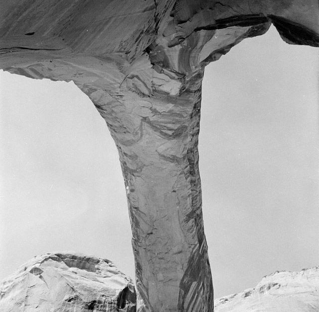
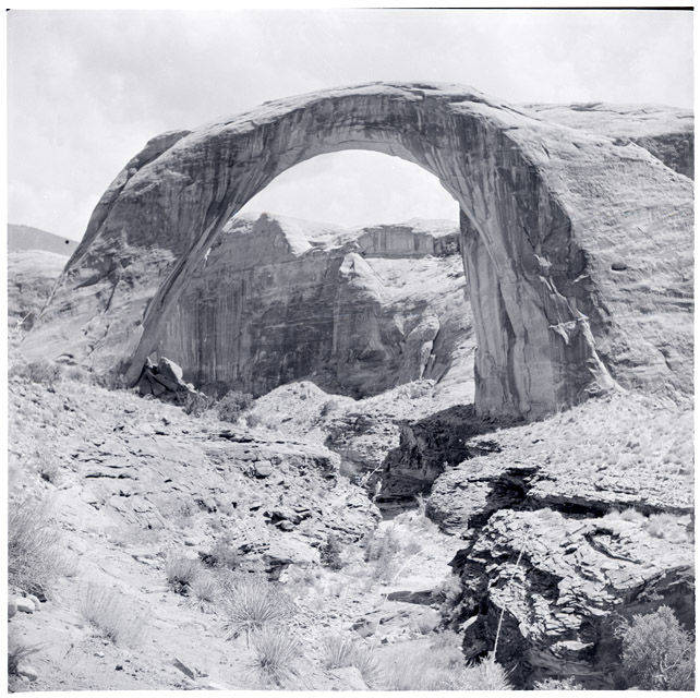
Rainbow Bridge
RAINBOW BRIDGE WAS never supposed to be flooded. Congress authorized Glen Canyon Dam’s construction in 1956 only after adding provisions that guaranteed Rainbow Bridge’s protection. These provisions explicitly stated that “as part of the Glen Canyon Unit the Secretary of the Interior shall take adequate protective measures to preclude impairment of Rainbow Bridge National Monument.” 19
The easiest way to protect Rainbow Bridge would have been to keep lake levels below 3,654 feet – but this is 46 feet lower than Lake Powell’s full capacity, and the Bureau of Reclamation proved unwilling to let their dam be used for anything less than its maximum potential. Instead, the agency promised to sandwich Rainbow Bridge between two cofferdams, one below the Bridge to keep out rising lake water, and a second one above the Bridge to prevent runoff from getting trapped behind the first.
The Bureau was, however, unwilling to follow through on this promise either. Then commissioner of the Bureau Floyd Dominy later confessed that although “according to law…we had to ask for money to build these structures,” he had “advised the appropriation committee that they would be foolish to give it to me.” The committee never appropriated the funds, the cofferdams were never built, and Rainbow Bridge was flooded. 20
As lake water seeped up under Tsé Naní’ áhiígíí, tourists arrived by the hordes, most of them on powerboats, many of them to party. They left behind great quantities of trash, played loud music, and they swam naked around and crawled up onto the Bridge. For many Navajo, to whom Tsé Naní’ áhiígíí is a deeply sacred site, such behaviors were defiling and intruded on their religious practices.
Navajo communities increasingly spoke out against the degradation of Rainbow Bridge, but when more water and more tourists continued pouring in, eight Navajo singers and three Navajo chapter houses turned took their concerns to the courts.
In 1974, the Navajo Legal Aid Society filed a lawsuit demanding that the Bureau lower Lake Powell, and that the National Park Service better manage tourist activity. The case, Badoni vs. Higginson, argued that by allowing Rainbow Bridge to flood, both with Lake water and with tourists, that the government had impeded the Navajo from freely exercising their religious activities, a right guaranteed by the First Amendment. “Rainbow Bridge,” the plaintiffs said, was “a religious symbol and a focal point through which many prayers and religious ceremonies derive meaning and vitality by reason of its role in the emergence of the Navajo people.” 21
The case was struck down, on the basis that the Navajo did not have a demonstrable “property interest” in Rainbow Bridge – that is, they had no title to the land or any other written record, legible to the U.S. court system, that could prove a property claim. Even by court standards, this is only partially true: an executive order by the U.S. government had added Tsé Naní’ áhiígíí and its surrounding lands to the Navajo Reservation in 1884, and then revoked that order in 1892. As the plaintiffs pointed out, this meant that the courts’ own records documented prior Navajo claims to the Bridge. Their appeal, however, was overridden when the court decided that the material and economic good that Lake Powell provided non-Indigenous people “outweighs the plaintiff’s religious interests.”
Once again, Westerners invoked a stratigraphic logic that naturalized and privileged settler encroachments while subsuming Navajo entitlements to an inert and bygone past.
But this instance of dispossession also exposes the role that the archive – and the way that the archive is defined – plays in power formation and territory-making. Derrida reminds us that the very word archive comes from the Greek Arkhe, which means both commencement and commandment. The earliest archives, he notes, were those places where official documents were stored, and called upon by the archons (bureaucratic magistrates) to “impose the law.” Those who create and guard the archive, Derrida says, retain the power of commandment. 22
When the courts asserted that the Navajo had no claims to Rainbow Bridge, the basis of this assertion – and the power to carry it out – was drawn from an archive that they themselves had constructed, and drawn also from their own systems of classification. An executive order of removal, they declared, was not a property title. Then certainly, neither oral stories, nor cultural memory, nor the petroglyphs, dwellings, or trails that attested to many years of Navajo presence in the landscape could count as a property title either.
Despite the power that resides in the archive, archive has no singular definition. Archives can be “a place where historical records are kept” (Cambridge English Dictionary) “collections of information” (National Archives) or “material preserved” (Merriam-Webster), and many other things too, depending who you ask. The difficulty of defining “archive,” I would argue, betrays its arbitrary nature; the archive is what those in power imagine it to be.
In my own efforts to grasp what an archive is, or what it might be, I take a cue from Leslie Marmon Silko and Puebloan understandings of meaning-making: “The ancient Pueblo people,” Silko writes, “sought a communal truth, not an absolute truth. For them, the truth lived somewhere within the web of differing versions, disputes over minor points, and outright contradictions.” 23
As I draw together the web of differing archival definitions, I have come to wonder: if an archive is a place that collects preserved material, what then, precludes generational memory (which resides in bodies of so many people, who collect and preserve bits of knowledge through time) or the land itself (a place that preserves, in material form, records of so many pasts) from being read as an archive? And by extending the definition of the archive, might power be released from the archons and distributed more evenly, to everyone and everything who keeps a record of the past? The web of stories will surely explode out, the truths that seem to anchor life as we know it will become unfixed and elusive, and the web will become tangled with disputes and contradictions, but somewhere within this mess will lie, if not a singular truth, a path that more carefully accounts for them all.
Proliferations
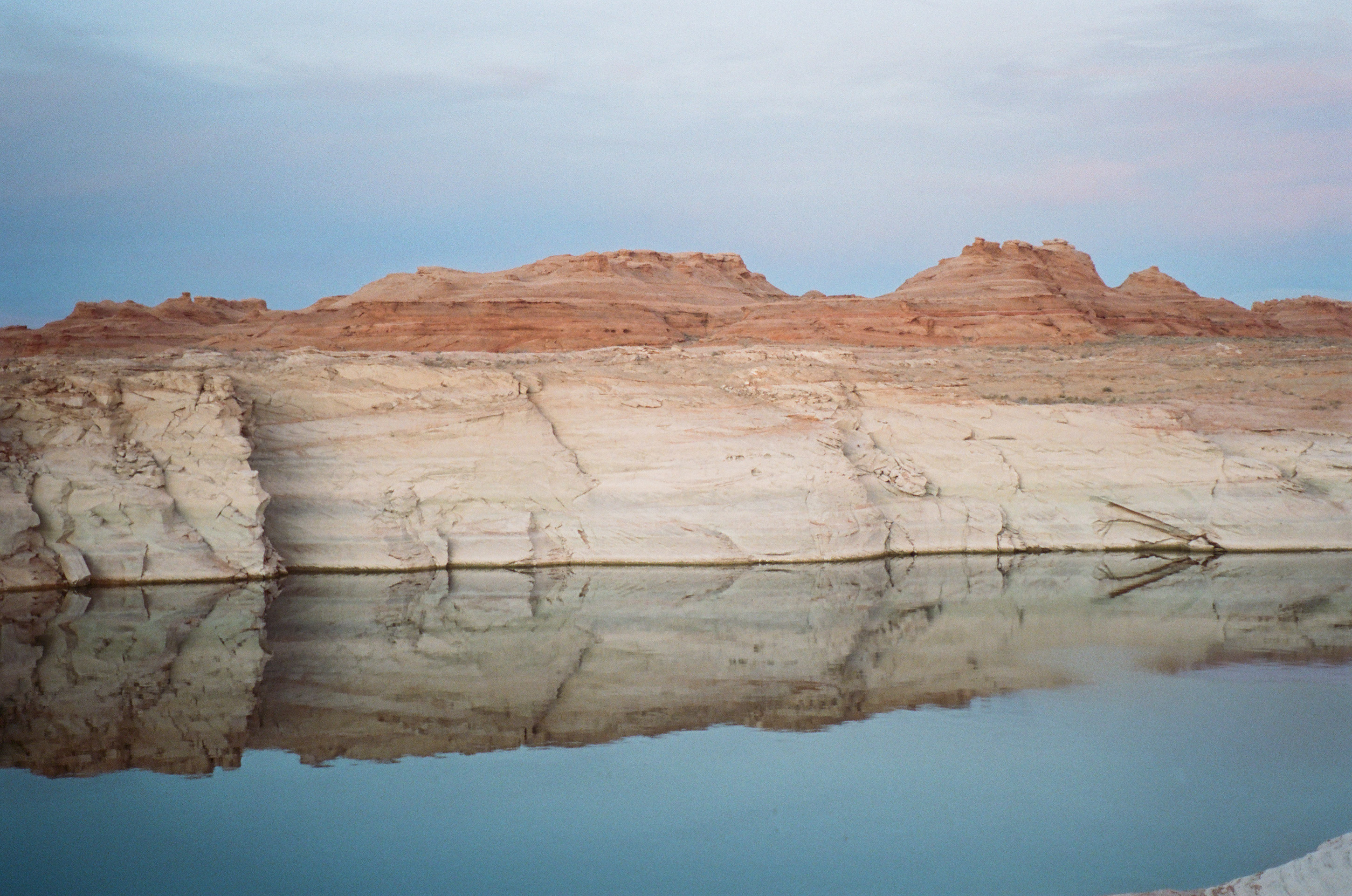
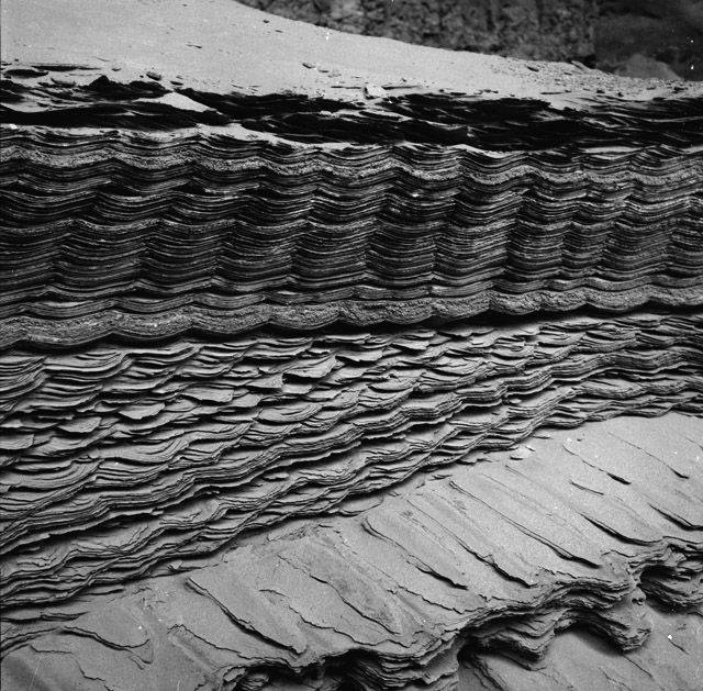
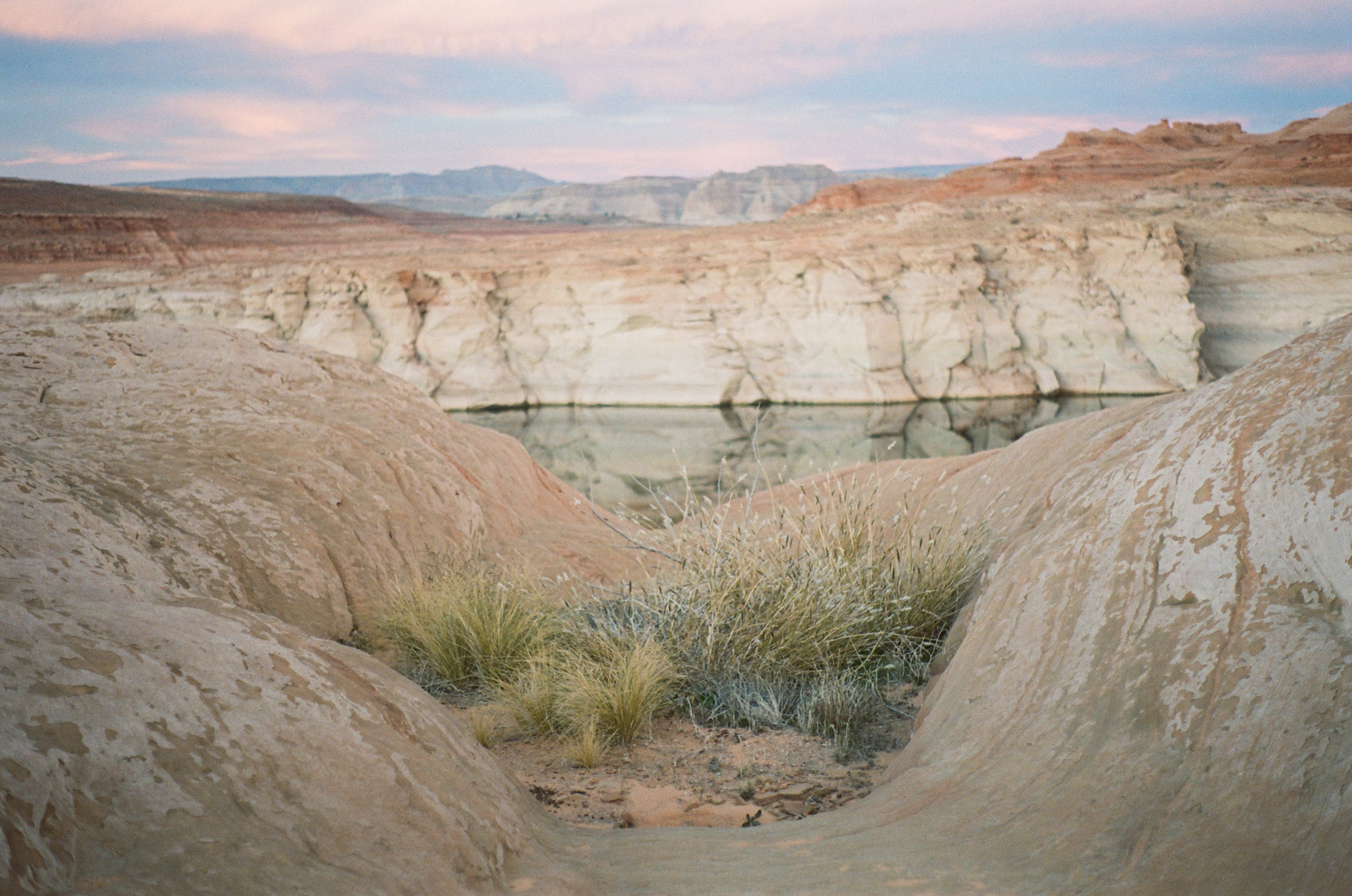
ALONG LAKE POWELL’S hems, where water meets cliff, bands of green scum cling to the rock. This is algae, bred in stagnant water, but not yet dried up by sun and air. Above these algal bands, the cliffs are chalked white with minerals, deposited by Lake Powell. At the bottom, closer to the water, the chalk is thick and solid, but it becomes patchier towards the top as it is flaked away by rain and wind. At the lake’s far edges, where the land begins to slope more gently to the water, thick beds of sand have heaped up into desiccated, crackled mud flats growing thick with tumbleweeds. Most of the lake’s shallow coves are choked with sucking muck, some of which is laced with pollutants spilled from upstream farms or uranium tailing ponds.
These are all agents of what Anna Tsing calls “feral ecologies” that is, “ecologies that have been encouraged by human-built infrastructures, but which have developed and spread beyond human control.” 24 Each agent carries out the mushrooming impacts generated by human infrastructure, and each serves as a reminder that environmental disturbances are rarely locally contained. And as they proliferate, each agent acts like territorial tentacles, marking every corner of the landscape as claimed, even if this claim is one of contamination and toxicity.
But – at the same time that Lake Powell’s algal blooms, sediment glaciers, lime encrustations, and tumbleweeds have become enrolled as agents of colonial territorialization, they are also saboteurs of this same project. Feral, after all, means to “escape from captivity” and as each of these entities explode out of human control, they remind us that even behemoth projects like the Glen Canyon Dam do not grant humans total power to command and manage every bit of nature. Life, new and old, will always spring up and lay claim to the cracks.
Remains of the Future
IN DECEMBER 2025, I drove from my home in the Idaho panhandle down to Glen Canyon. This is a seventeen-hour trip, so I stopped halfway for a few nights in a small town along the western skirts of the Tetons, hoping to cross-country ski for a few days. I arrived to find the valley bare and dry—which, given the string of sunny, fifty-degree days wasn’t so much surprising and disconcerting. Even upper reaches of the foothills were crusted only a thin and scratchy layer of snow. I skied once, clattering over chundered trails, then searched the internet for other things to do.
By some strange coincidence, or perhaps some invisible pull, I had unknowingly driven myself straight to the site of one of the worst dam disasters in United States history.
Almost exactly fifty years before, in November of 1975, the Bureau of Reclamation had completed an earthen dam in Teton Canyon – despite the alarm of their own engineers and geologists, who warned that the canyon was riddled with fissures and porous rock. But the Bureau, emboldened by their decades-long streak of building improbable dams (like Hoover and Glen Canyon) simply caulked the rifts with grout and proceeded as usual.
The reservoir reached full pool seven months later – and immediately collapsed. 80 billion gallons of water moving at 2 million cubic feet per second surged out from the reservoir, chewing open the dam walls to rip across the plain in a flood 15 feet high and four miles across. Two towns were wiped clean from their banks. Eleven people and 16,000 livestock drowned.
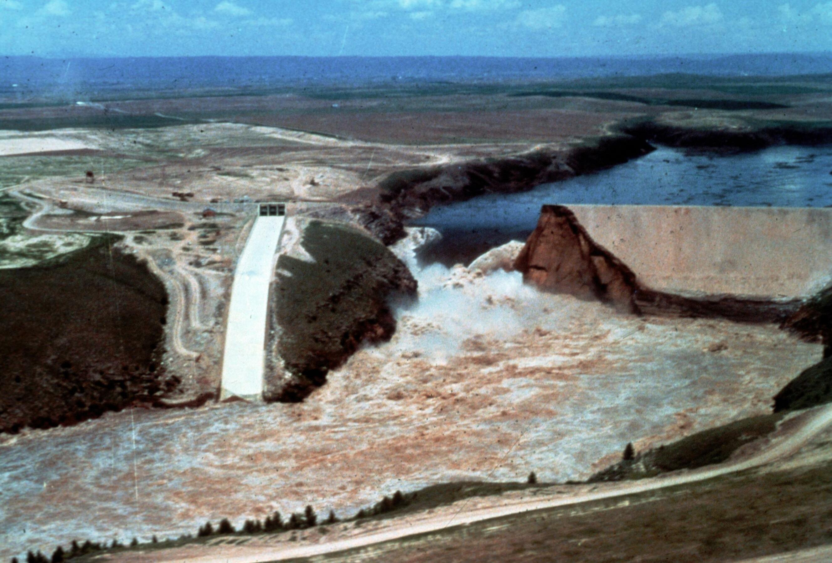
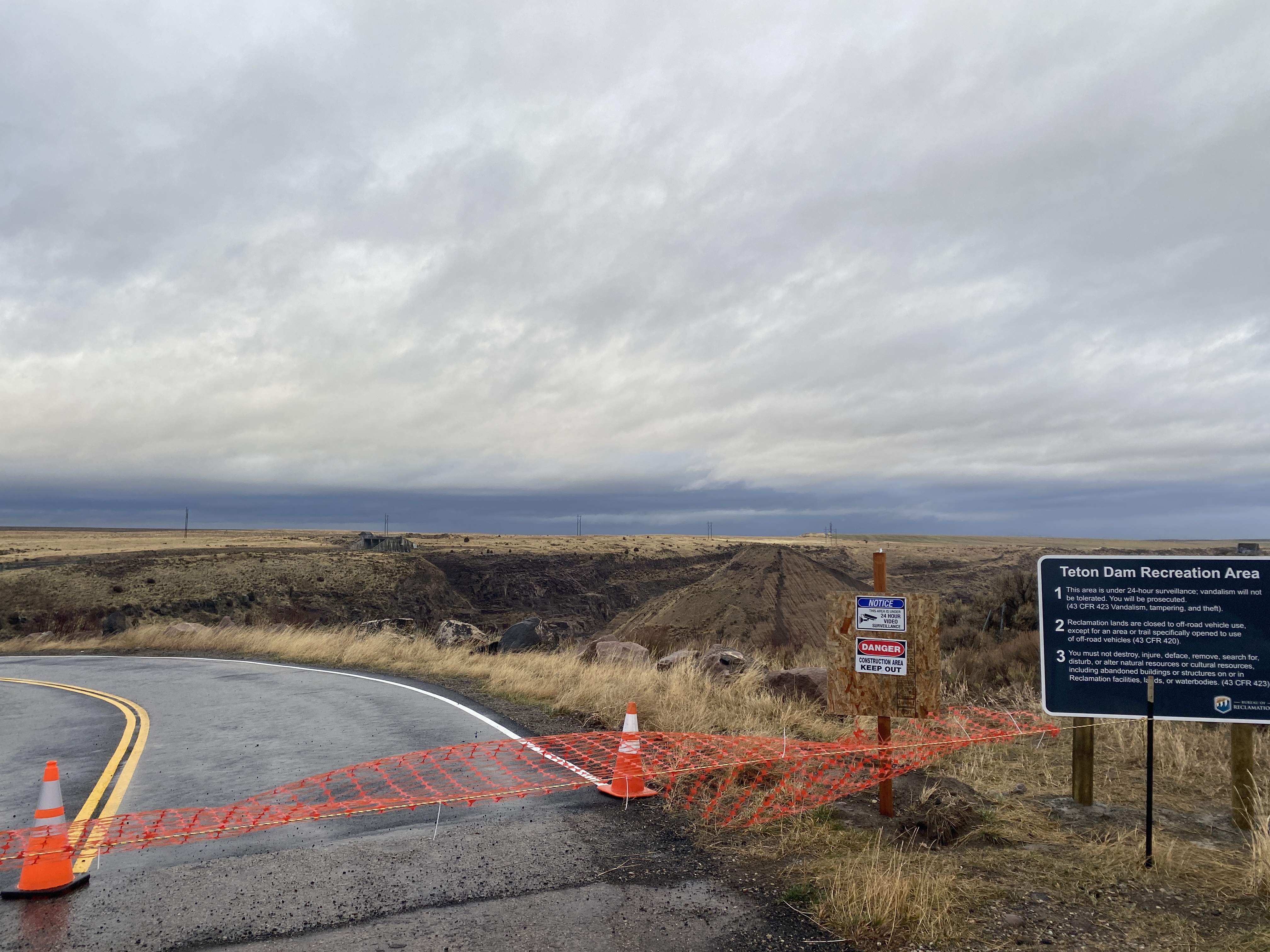
The morning I went to the dam, or what remained of it, a record-breaking windstorm was pummelling the Pacific Northwest. I fought to keep my car straight against eighty-mile-per-hour gusts, wondering if I should turn back, but then I was there: a small brown sign on the side of the highway pointed down a broken, almost invisible road. I eased down it slowly, swerving between potholes and rough heaves. In some spots, dirt had crawled out onto the pavement, covering it entirely. Abruptly, the road stopped, cut off by orange construction taping, and dropped promptly into the canyon.
I sat in my car for a moment, which was rocking in the heavy wind. Perhaps it was the apocalyptic weather – the grey yellow skies and the tumbleweeds shooting across the plains – or the signs posted all around announcing that I was being surveilled, or the thick rusted pipe at the edge of the parking lot that looked as if it had been hurled up by the flood, or perhaps it was knowing that I was in a place that, fifty years before, had experienced such a cataclysmic disaster, but I began to feel a deep dread. When I pushed my door open, it was flung violently back by the wind, and I had to fight to close it again. Then I started down a rutted dirt trail towards the dam.
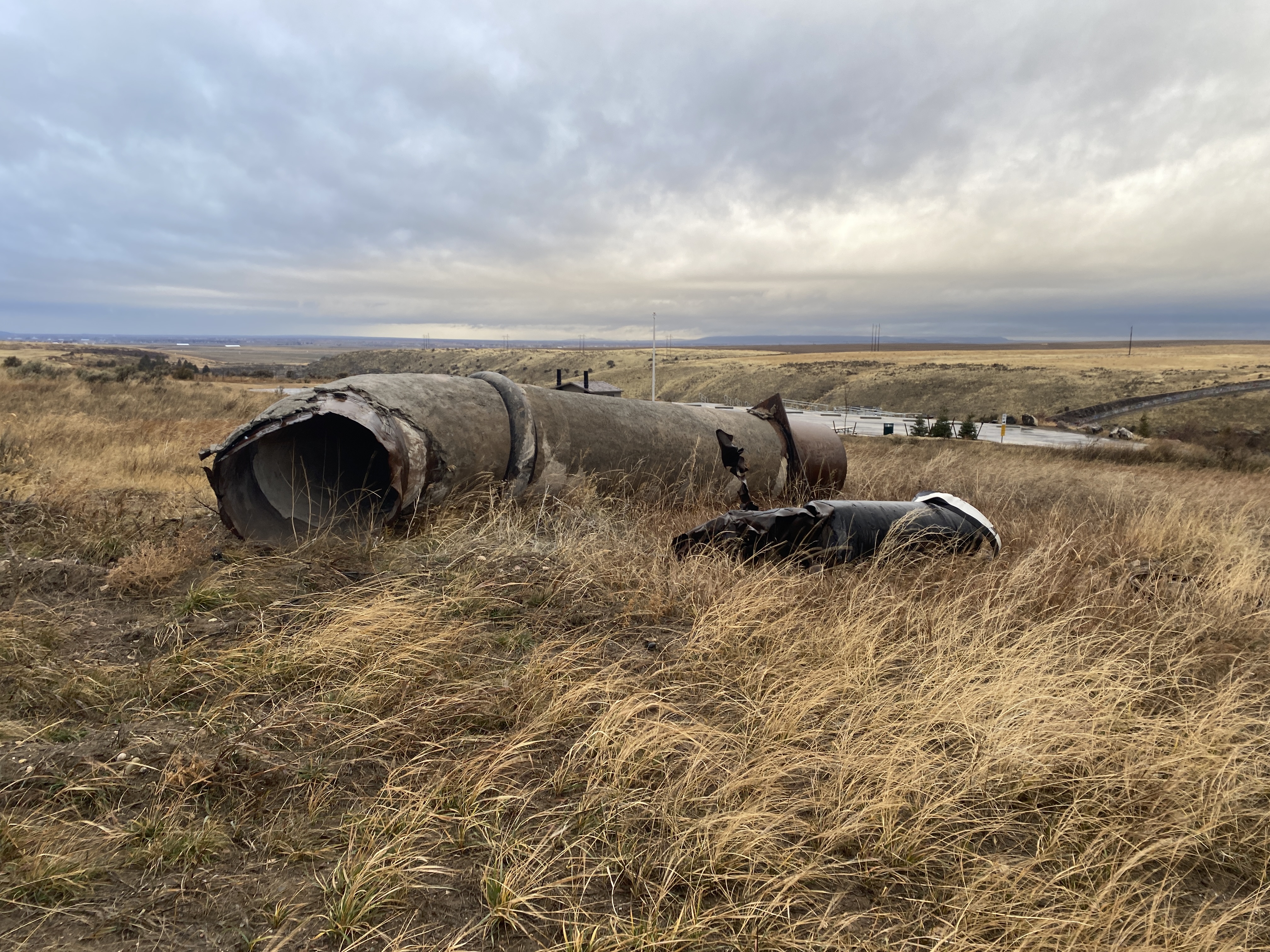
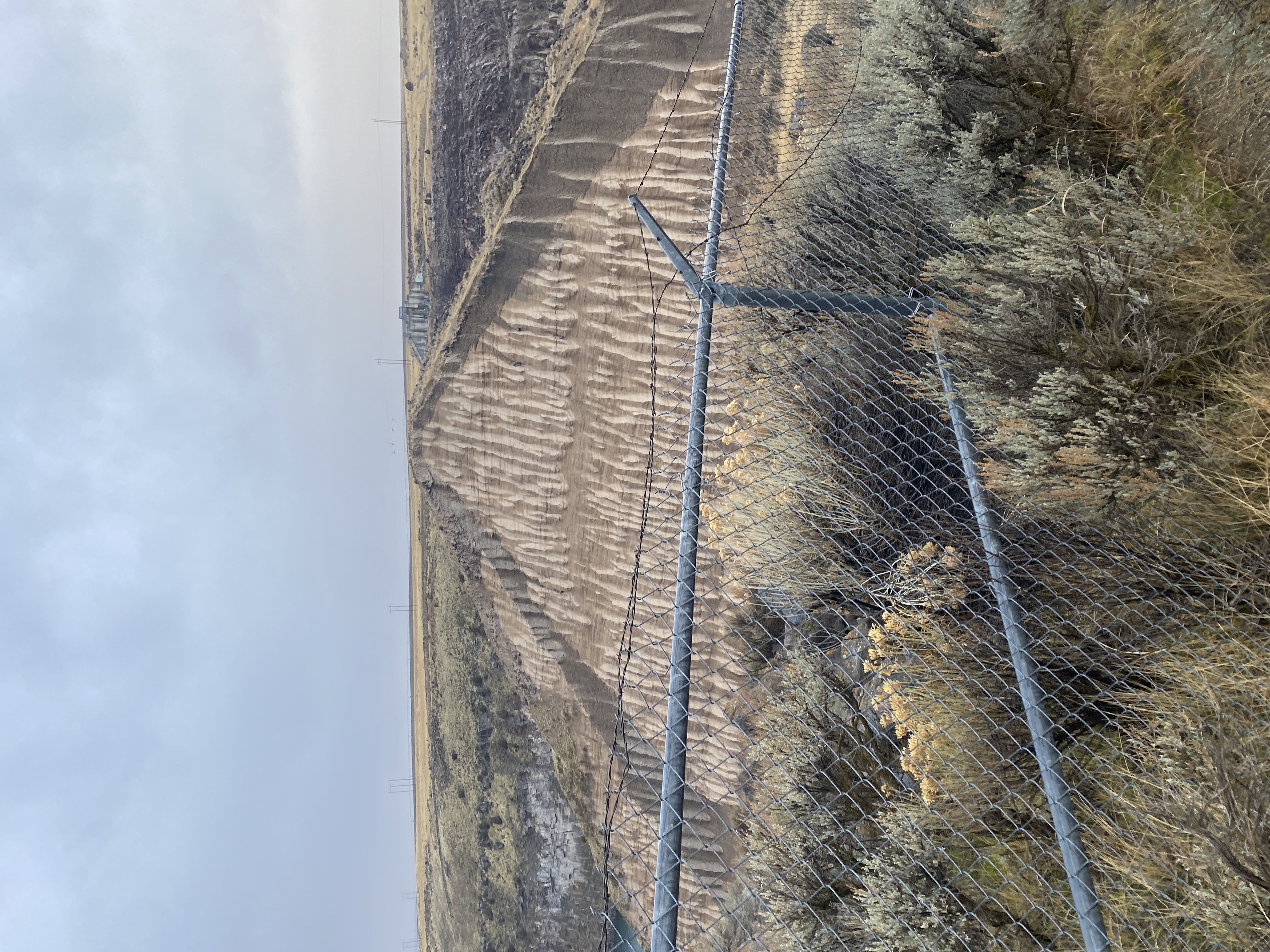
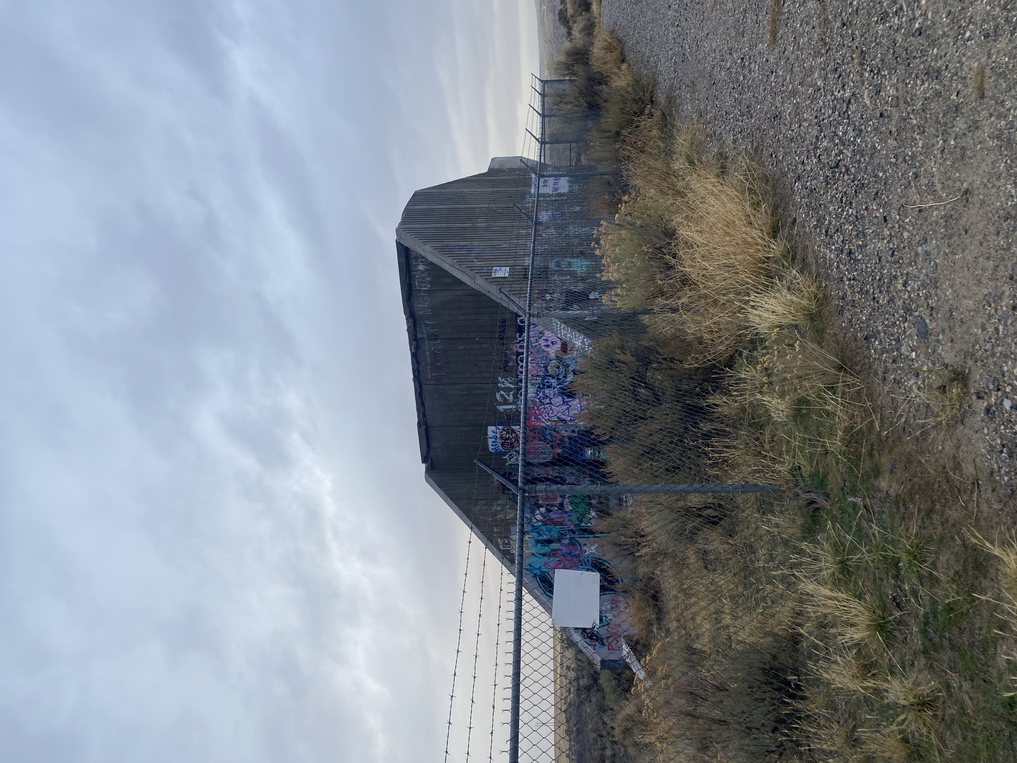
The wind howled low. It began to rain, and I nearly turned back, but the wind was pushing me forward. Eventually, over a small crest, the dam came into view. What remained was a stark and ugly cone with its face cut cleanly off, rising up from the canyon floor. On either side of the canyon stood concrete abutments, though whatever they had abutted had long ago been torn away. They were scrawled with graffiti and circled by a chainlink fence that had been repeatedly bent back by people who wanted to get in, for whatever reason. I turned down the valley, and saw the path of the flood – a vast scar, walls bared and scoured and crumbling in.
A gust of wind whipped down the plains, this time bringing rain sideways, and the fence rattled and screeched. I am not a person who is easily frightened by extreme weather, or by being alone in remote places—and I cannot remember ever feeling the kind of panic I felt then. I should have stayed longer, to take more detailed field notes, or take more pictures, but I couldn’t. I ran as fast as could, against the roaring wind and rain back to my car, and drove away.
All dams are temporary, and all dams, one day, will crumble into bald and torn up heaps, blasted by wind and water and time. Eventually, every dam on the planet will dissolve completely; concrete will be carried bit by bit out into the sea, rebar will be buried beneath water and sediment, and whatever is left will pulled apart by plant roots and microbes. But for a long time, the ruins of these great infrastructures will preserve traces of who we humans, at this moment, were.
What remains of ourselves are we leaving to the future?
Works Cited
-
Ogden, Laura A. Loss and Wonder at the World’s End. Duke University Press, 2021, pp. 32-33. https://doi.org/10.1215/9781478021865 ↩
-
Ogden, pp. 23, 27 ↩
-
Derrida, Jacques. Speech and Phenomena: And Other Essays on Husserl’s Theory of Signs. Northwestern University Press, 1973, p.4. ↩
-
Powell, John Wesley. “The Irrigable lands of the arid region” The Century Magazine, 1890 ↩
-
Powell, John Wesley. The Canyons of the Colorado Flood & Vincent, 1895, p. 321 ↩
-
Powell, p. 108 ↩
-
Powell, p. 184 ↩
-
Bsumek, Erika Marie. The Foundations of Glen Canyon Dam: Infrastructures of Dispossession on the Colorado Plateau. University of Texas Press, 2023, p. 6 ↩
-
qtd. in Bsumek, p. 28 ↩
-
Powell, p. 108 ↩
-
Bsumek, p. 86 ↩
-
Bsumek, p. 61, 67 ↩
-
Pasqual, Teresa. Communities of Movement: Ancestral Puebloans. World History Project, 2023. ↩
-
Meko, D.M., Woodhouse, C.A., Baisan, C.A., Knight, T., Lukas, J.J., Hughes, M.K., and Salzer, M.W. “Medieval Drought in the Upper Colorado River Basin.” Geophysical Research Letters. 34, L10705, 2007. https://www.treeflow.info/content/colorado-r-lees-ferry-az-meko ↩
-
Silko, p. 33 ↩
-
Silko, p. 35 ↩
-
Bsumek, p. 68 ↩
-
Luckert, Karl. Navajo Mountain and Rainbow Bridge Religion. The Museum of Northern Arizona, 1977, p. 148. ↩
-
United States, Congress. “Upper Colorado River Basin; Purpose of Development of Water Resources; Initial Units; Construction of Wayne N. Aspinall Unit Contingent Upon Certification; Participating Projects; Rainbow Bridge National Monument.” United States Code, title 43, chapter 12B, § 620, 2011 ed., U.S. Government Publishing Office, www.govinfo.gov/app/details/USCODE-2011-title43/USCODE-2011-title43-chap12B-sec620. ↩
-
Powell, James Lawrence. Dead Pool: Lake Powell, Global Warming, and the Future of Water in the West. University of California Press, 2020, p. 131. https://www.ucpress.edu/books/dead-pool/paper ↩
-
National Park Service, “Chapter 5: Issues and Conflicts I: Rainbow Bridge Religion and Navajo Legal Claims, 1863-1998” Rainbow Bridge National Monument Administrative History, 2008. ↩
-
Derrida, Jacques, and Eric Prenowitz. “Archive Fever: A Freudian Impression.” Diacritics, vol. 25, no. 2, 1995, pp. 9–63. JSTOR, p. 10. https://doi.org/10.2307/465144 ↩
-
Silko, p. 32 ↩
-
Tsing, Anna. Feral Atlas: The-More-Than-Human Anthropocene, 2021. https://feralatlas.org/ ↩