

WATER
Ghosts of Water Past, Present, and Future
IN 2021, I was hired by the Arizona Conservation Corps to lead trail and saw crews on projects across the state. Our work, for the most part, was aimed at mitigating the omnipresent threat and cyclical destruction of either water or fire. We dug drains and sunk water bars into trails. We circled flood-prone homes with sandbags, or repaired sandbag walls that had failed during the last monsoon. We thinned overgrown forests, hoping to keep the fires sure to come from climbing up into the canopy. We spent a lonely ten days in the Pinal Mountains, which had been completely scorched during a fire in 2017, and we tried to repair what trail we could.
We rarely encountered water or fire in the field, but we thought about both constantly. We imagined how rain might run down a trail – would it catch in our drains or gully out the trails? We tried to envision where, in our little tract of forest, a fire could climb up a tree’s branches and into its crown, or hop from one tree to the next. We moved like fire and thought like water, knowing both would come – as they had before – and we tuned our work to their imagined flows.
We examined breaches in flood barricades, where a flood had tossed aside the sandbags like marshmallows and ripped through a person’s home, splattering their walls and furniture with smelly mud. We tried to heap the sandbags taller, and pack them more tightly, so that our new barricades might hold against the next monsoon.

In the Pinals, we were haunted constantly by the burnt stench of ash and char – though the fire had been quenched four years ago – and by the silence, the near dearth of other life. Under the hot, shadeless, soot-laced air, surrounded by the skeletons of so many heat-shriveled trees, we were always thinking about the flames. We could imagine the inferno, the dark clouds of roiling smoke, the crackling, molten earth much more easily that we could imagine what the mountain had looked like before.
During the heat of the summer, we were sent to do trail maintenance along the North Rim of the Grand Canyon. We camped by the canyon’s lip, tucking our tents into a dark ponderosa grove near the mule barns. The trees held back the desert sun from above, but our camp was constantly backlit by the canyon. Its sea of terraced rocks refracted the sunlight and sent it streaming sideways through the trees. Sometimes at sunset, we sat at the very edge of the canyon, and although we could not see the river, its presence was written on the face of every terrace, butte, and temple, in the abysses that stretched between them, and in the light that that the canyon bent into our camp.

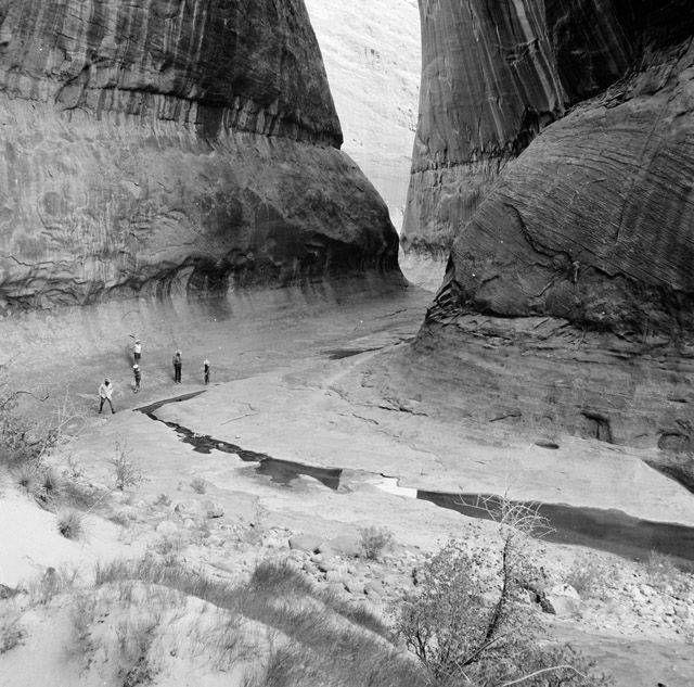
Each morning at the North Rim, my crew and I gathered up our packs and our tools, and descended together into the canyon’s maw. We hiked for over an hour to reach our work site; down a switchbacked trail to a narrow suspension bridge slung over Roaring Springs Canyon. We never saw any water there, nor did we ever see the Colorado River; the river was tucked still further down in the belly of the chasm. Despite the 2,000 foot cliffs that now loomed high above us, the canyon’s lower terraces seemed no closer to us now than they had at the rim. A vast mazeway of space flowed out around us, curling like the river through the canyon’s mesas. I felt myself suspended midair, engulfed by the massive channels cut by the river and its tributaries. The river itself was nowhere to be seen, yet I felt constantly aswim in its presence.
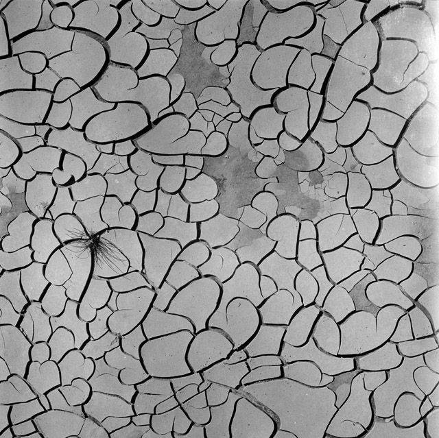
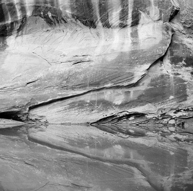
I spent the early days of my research for this project pouring over archival photographs of Glen Canyon, looking for images that seemed to glint with a presence or a story – of its people, animals, plants, winds, water, its geology. In most of the images, however, water was hardly present, or present only in a trickle. When the river did appear, it was as a flat sheen or a grey riffle. These opaque, inscrutable, often mundane surfaces revealed little about the great work the river had done over millions of years to carve out the basin’s canyons, to nourish its life. The river’s histories were instead made evident by the tracks and traces the river left in its wake – in the smooth tunnels it chewed open in the earth, in the mud flats crackled open by evaporated water, in the tricklings traced through sand, in the drip-stained walls which flowed from rocky seeps, in the very existence of trees, grasses, life.
In Glen Canyon, water seems writ in all places – although oftentimes, it is written only in a trace, as a kind of absence of presence. It is almost as if the entire landscape has been molded around water; where it is, where it has been, or where it might come again. Looking through the archive, I felt myself once again aswim in watery space; in the world that water had left behind, and in a world that I knew had since been completely inundated after the creation of the Glen Canyon Dam.
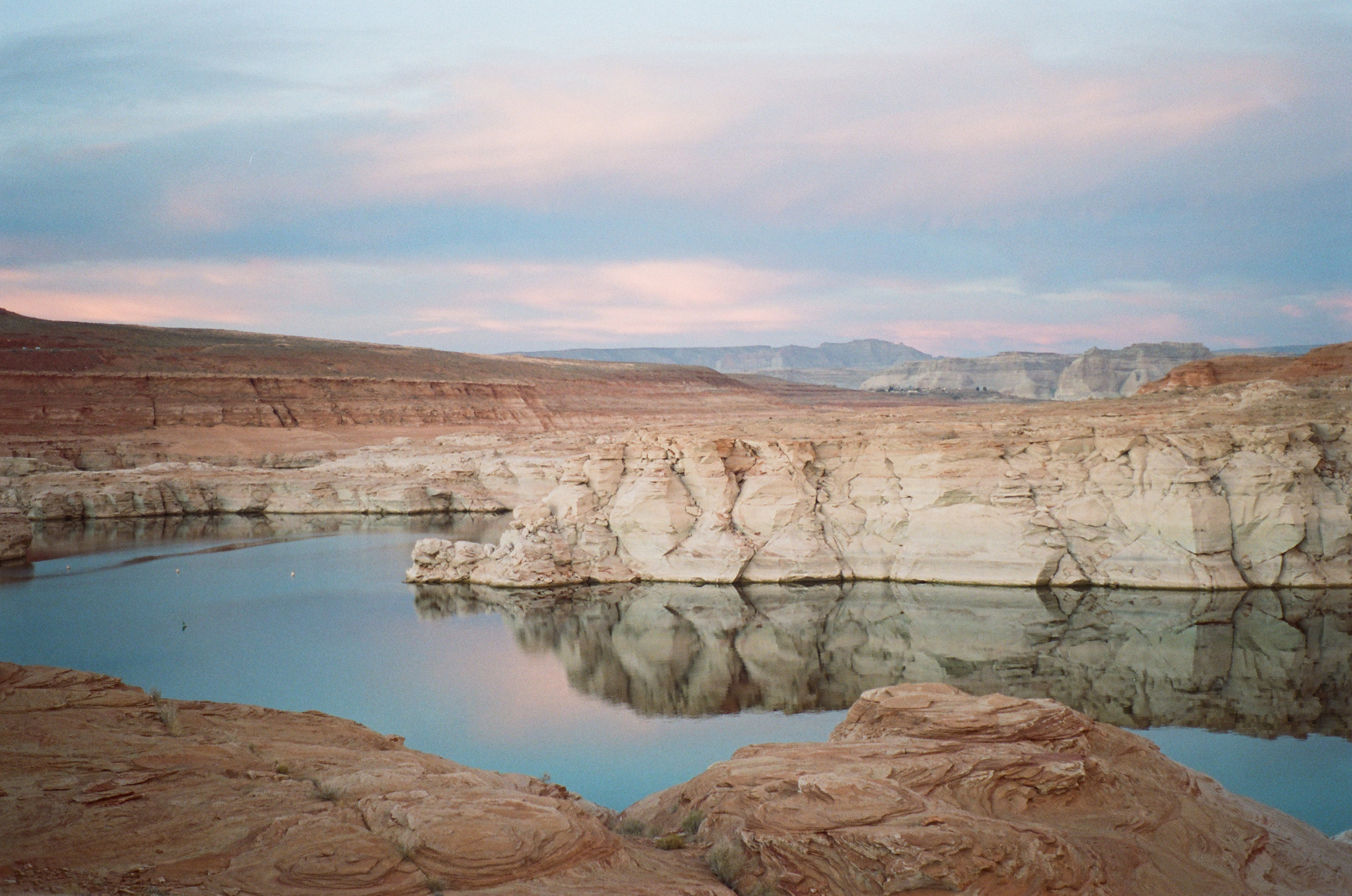
Four years after I left the Conservation Corps, I returned to the Colorado River Basin to conduct field work for Sedimentation in Page, Arizona, which is home to the Glen Canyon Dam. I arrived to my hotel late into the night, having been slowed by a historic wind storm that was sweeping across the west that day. I had reserved a lake view room, although I had been warned by the booking platform that “view rooms may have limited views due to declining water levels.” The lake was at a historic low that year, and I wasn’t sure how much water would be left in its outer bays.
When I threw open my curtains in the morning, I was pleased to see the lake spread below me, turned softly pink by the sunrise. But between the lake and I lay nearly a quarter mile of crusty sand flats, clumped with russian thistle and laden with rusted boat chains. Across the lake, I could see pale bathtub rings painted across the cliffsides, which marked full pool levels from over twenty years ago. Here again was that familiar feeling, suspended between where the water really was, and where it had drained away.
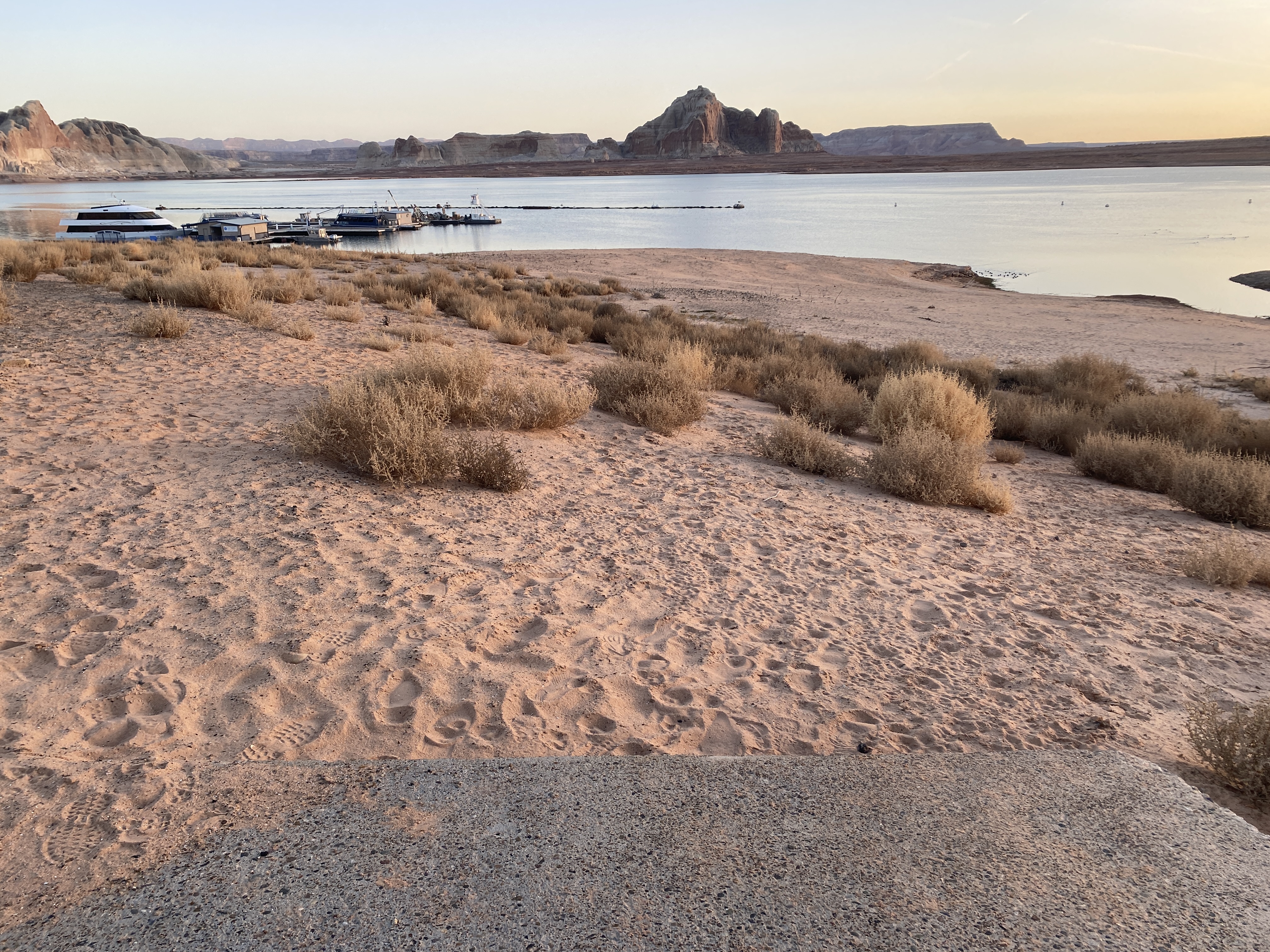
This feeling remained throughout my visit to Lake Powell. Everywhere and everything in Page seemed to be held adrift in the space that lay between water’s presence and its absence. There were closed marinas, shuttered businesses, parking lots full of houseboats perched on stilted blocks. All of these scenes marked the physical disjunctures between watery hopes and watery realities, and many of the people I spoke with during my trip seemed similarly caught between these worlds.
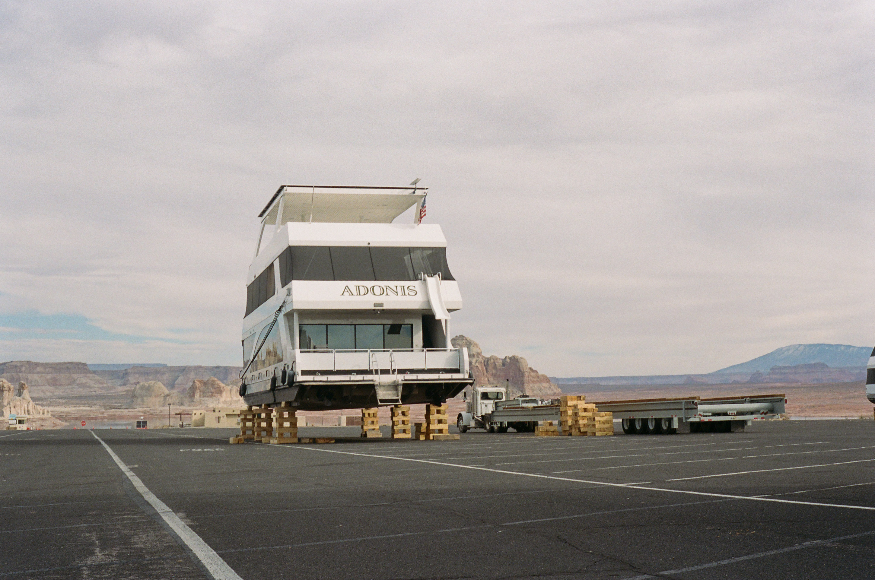
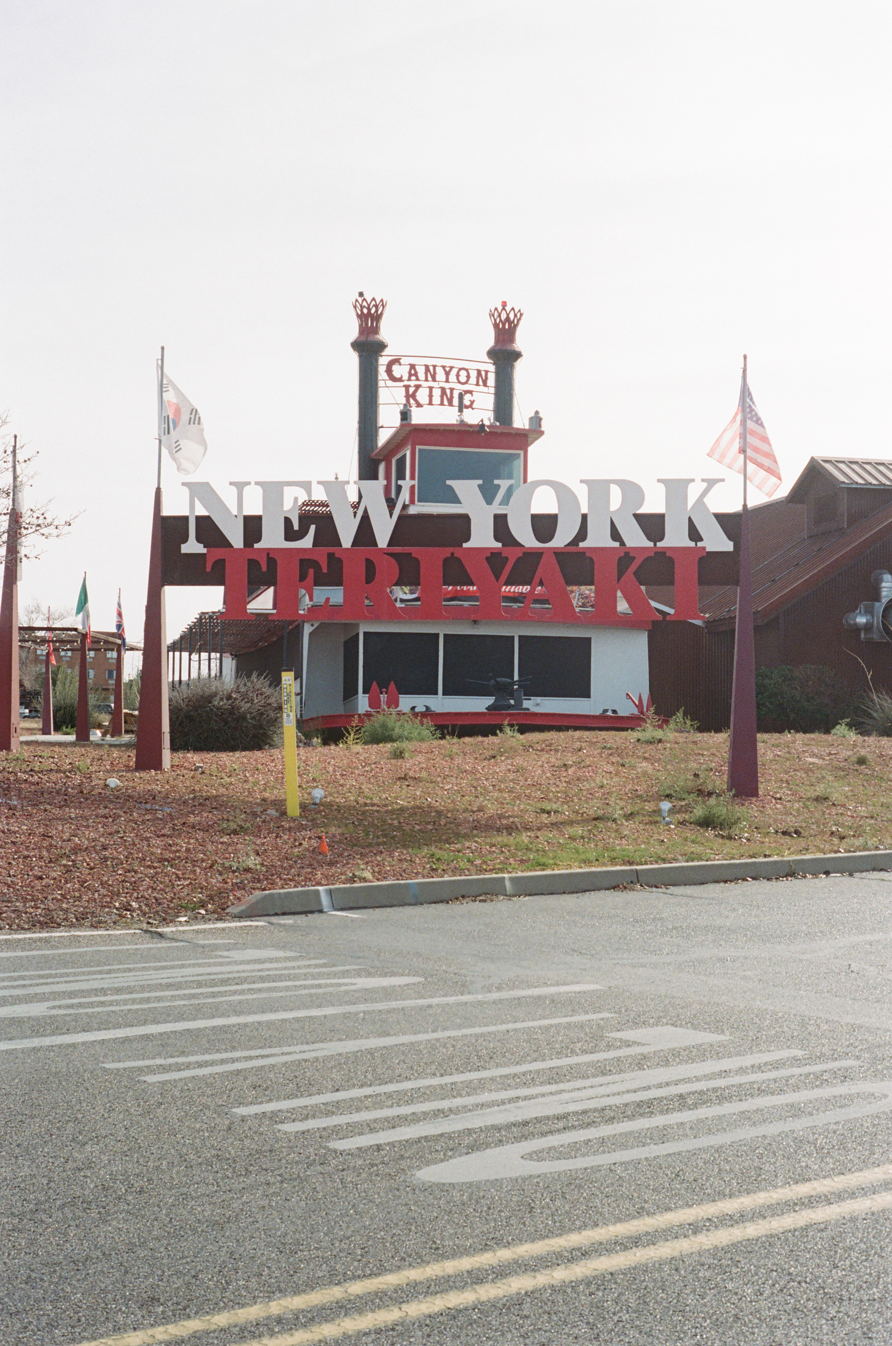
One evening, the hotel bartender showed me a binder of old photographs from when the lake was last at full pool. There was one photograph of the hotel’s north wing, where I was staying, and in it, the lake was practically lapping at its walls – I could have jumped from the balcony of my room into its waters. In another photograph, there was the hotel swimming pool, with a boat called The Canyon King docked immediately beside it. I recognized the boat – The Canyon King was now parked in a shopping plaza lot just outside of town, and had since been converted into a New York Teriyaki Restaurant.
The bartender hadn’t been here then – he had been a child in Alabama during the last full pool – but he spoke about that other world, full of water, with the kind of nostalgia that seems intent on drawing the past across the expanses of time and into the present. Then he would swing around, and suddenly we were in the future, talking about the rains and snowmelt that would surely, some day come again and refill the lake.
Page was strewn not only with relics of past water, but with the totems of future water. There were signs in my hotel bathroom that urged unlikely water-saving practices (turn off the shower while you soap). There were reminders to recycle written across the hotel dumpsters (Recycling just 1 ton of cardboard will save 7,000 gallons of water). Boat tour booking platforms allowed me to reserve a trip up a currently dried-out canyon a year from now, ostensibly betting on a wet winter. Guarding the hotel entrance was a wooden snowman painted with the same hope – to Let it Snow!. If it snows, if you recycle enough, if you take shorter showers, these items declared, we might still imagine a future in which the reservoirs are full, in which the boats are anchored out in the lake instead of parked in a shopping plaza, and in which everyone can drink and turn on the lights.
All of Page felt suspended in the widening chasm between its existent water – the disappearing lake – and its imaginations of water – water as a memory or as a hope for the future.
In some ways, this is nothing new. Existence in arid regions, where water’s presence is not constant but cyclically volatile, often necessitates living patiently and resourcefully in the spaces between water’s pulses. Nonhuman organisms persist in arid regions through survival mechanisms that allow them to wait out long intervals of dryness. Succulents store water in their pulp, mesquite trees can push their roots up to 200 feet into the earth to draw on underground water tables, certain microorganisms can dry out their bodies completely while they wait for water to return. And Indigenous populations have survived in the arid southwest for millennia by practicing cyclical migration, through intimate acquaintances with seeps and springs, and by developing sophisticated water management systems that included reservoirs, irrigation canals, and terraces.
What is new for the Colorado River Basin is the creation of physical and societal infrastructures that instead expect water cycles to hold relatively constant.
In 1922, delegates from each of the basin states – Wyoming, Colorado, Utah, Arizona, Nevada, New Mexico, and California – convened at the Bishop’s Lodge in Santa Fe, New Mexico (which is technically located in the Rio Grande River Basin) to divvy up the Colorado River’s water between them. They estimated, based on just 27 years of data, that the river carried an average of 16.4 million acre feet (MAF) of water per year. This number turned out to be an egregious overestimation – a fatal error that has often been chalked up to an ironic trick of timing, as the compact was signed during a wet cycle. As Eric Kuhn and John Fleck point out, however, the delegates were in fact forewarned that their math was bad from the beginning; hydrologist Eugene LaRue had written the commission, as well as then-Secretary of Commerce Herbert Hoover to alert them that their number was 10% too high. The river, according to LaRue, showed an average of 15 MAF per year, and he pressed decisionmakers to be even more conservative than that in order to account for long-term fluctuations. 1

Indeed, attempting to guess the Colorado River’s yearly flows based based on an average projection is like throwing a dart a moving target. Water availability in the basin oscillates wildly according to regional climatic patterns; in 1941, for example, a gauge at Lee’s Ferry registered a yearly flow of 18.2 MAF. The year before, that same gauge clocked just 9.4 MAF, meaning the river’s average yearly flow almost doubled in the span of just 12 months. 2
Rather than allocate water based on a percentage of available supply (which would have encouraged more adaptive consumption practices), however, the commission instead drew an arbitrary line between the basin states at Lee’s Ferry, and portioned out a fixed volume to each basin: 7.5 MAF to the upper states, and 7.5 MAF to the lower states. The Colorado River, the commission decided, would bring 15 MAF to the basin each year, an amount that left absolutely no room for error beyond La Rue’s projections. In this way, the commission wrote into law an inevitable gap between the river’s actual water and its legal water. They knew that some years the river would carry less than 15 MAF, and signed the papers anyway.
Kuhn and Fleck purport that the commission’s decision to ignore the scientific evidence available was not an oversight but rather a political maneuver. By overestimating the river’s flows, each state could stake a larger claim to the river’s water. Water law in the Colorado River Basin appropriates water rights according to a first use doctrine – that is, the first party to use the water earns the rights to it. By 1922, however, states like Wyoming and Colorado had nowhere near the population or development levels already established in California, and the states feared that if they didn’t lay their claims soon, California would obtain rights to almost the entire river, foreclosing the other states’ potential for growth. The compact secured the upper basin states’ future, and the on-paper water that the upper basin received paved the way for its ensuing development.
The chasm between actual water and allocated water, then, was not a bug but a feature of the Colorado River Compact; the compact invented a new kind of water imaginary which abstracts material water into paper water that may be allocated, traded, and negotiated separate from actual water flows. In doing so, the commission wrote into existence a liminal world that existed between material water and water on paper, and it was in this world that Western development took place – and it is in this liminal world that Southwesterners now live.
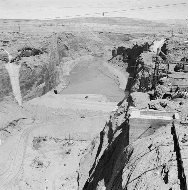
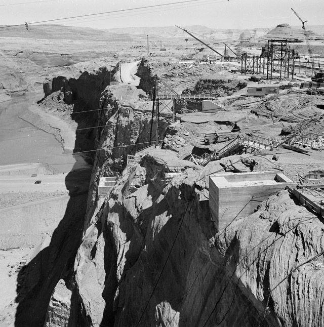
Of course, there eventually comes the problem of delivering wet water (as it is called) to water holders who would eventually cash in their water claims, if all went according to plan. But this was not, until recently, so much a problem as another advantage to Western development. To close the gap between paper water and wet water, particularly during low water years, the commission proposed a series of dams to be erected along the Colorado River. During high flow years, the dams would catch excess water and store it as a savings bank for low water years. On the surface, this seemed a rational enough plan – water storage is an age-old survival tactic employed not only by humans but non-human beings (Gila Monsters, which are native to the Southwest, hoard water in their bladders, for example, to utilize during dry spells). And so nine years after the compact was signed, construction began on the Hoover Dam, and in 1963, the Glen Canyon Dam was completed under the same pretenses.
Both projects were boons to Western development schemes, and both were proposed as necessary if the compact was to meet the water obligations that the commission themselves created. In addition to storing water, the dams would generate hydroelectricity, provide flood control, inject government money into local economies, and as geographer Andrew Curley argues, serve as “colonial beachheads” that worked to further “lasso” Indigenous populations into “colonial socio-political arrangements.” 3 Thus, it was compact’s gap between actual water and paper water itself that created the evident need for hydro-development infrastructure, even if this gap was an arbitrary invention of the state itself.
The invention of paper water also enabled the state to skirt its legal obligations to deliver water to Indigenous nations, for it allows the state to acknowledge Indigenous water rights on paper while withholding the infrastructure to deliver wet water to Indigenous lands. While the 1908 Winters Doctrine asserts that many Southwestern tribes possess senior water rights, and while additional treaties and land swap agreements have continually promised water infrastructure to the basin’s tribes, many tribal communities still have no way to actually access water from the Colorado River, as the government has continually delayed building the water distribution infrastructure they pledged in exchange for Indigenous lands. For the Navajo Nation, whose tribal lands directly abut Lake Powell but do not include even a drop of it, this absence of infrastructure transforms a thin border into a chasm – Navajo Nation is literally bordered by water, and on paper has senior rights to the river. But without the proper infrastructure, Navajo Nation has been left little recourse for transforming paper water into wet water.
If the space between legal water and material water is bridged by technoinfrastructure, then these infrastructures can equally become tools for channelling sociopolitical power or withholding it.
One can thus follow the lines of power in the basin by tracing its water infrastructure – and nowhere are these channels of power made more evident than in the Central Arizona Project; a 336-mile-long diversion canal which pumps water from Lake Mead 3,000 feet uphill to serve the cities of Phoenix and Tuscon. This project began first by allocating paper water to places where the Colorado River had never touched, and then by building the infrastructure to materialize these paper flows. But this system relies on vast amounts of electricity in order to move water uphill – electricity that, until 2019, was produced by a coal-fired power plant on the Navajo Reservation, which used coal from the Kayenta Mine. The Kayenta Mine is also on the Navajo Reservation, it used water pumped from the Navajo Aquifer to transport coal in a slurried stream to the power plant. The Navajo Generating Station (NGS) imparted massive amounts of pollutants into the air, increasing the risk of respiratory disease for local residents, 4 but it also employed nearly 1,000 people, 90% of whom were Navajo. Its closure, incited by a transition to natural gas had devastating effects on the local economy.
Paper water, however, does not deal with the material corollaries required to transform itself into wet water. Paper water imagines water as distilled into its purified, isolated form, as H20, when in reality, water is always mixed up with other substances, and moving water 336 miles and 3,000 feet from its natural bed only entangles more matter and bodies into its flows. But for water to get from Lake Mead to a tap in Phoenix, coal had to be blasted out of a mountain, an aquifer drained, lungs and airscapes polluted, and economies built and collapsed. By creating an imagination of water as abstract resource, however, the social and ecological contingencies that are always required to bring water into being are rendered invisible.
Since the turn of the millennium, the gulf between the compact’s 15 MAF and the actual water in the Colorado River has grown increasingly wide. In 2026, the river is expected to carry only .8 MAF, and Lake Powell has little reserves left. Some of this discrepancy is due to overallocation – the forcing of the river to conform to an imagined ideal number – and much of it has been incited by the very relations that the compact ignored when it imagined the river’s water as a resource. Global temperature increases, spurred by the kinds of development projects that the compact sought to enable, have produced a historic megadrought. This not only means less water input to the river each year, it also means that parched soils and plants are absorbing more of the water that does flow towards the river, and more water is evaporating off the faces of its reservoirs.
For many communities in the basin, this gap is not yet tangible – water is still flowing out of Lake Mead into Phoenix taps and spilling from irrigation canals across alfalfa fields. Water imaginaries still align, in these places, with material water flows. But on the very day that I write these words, the U.S. federal government announced plans to slash water allocations to the lower basin states by up to 40% in the upcoming year. Then, as in Page, life across the basin will be caught in the space between watery hopes and memories and watery realities.
We cannot produce water where there is none, nor can we disentangle water’s flows from the mesh of other matter and beings that direct its cycles. But we can close the rift between the water we imagine – water on paper, water as H20 – and water as it really exists – as wet, as mixture, as life.
We might still find ourselves aswim in the chasms between water’s pulses – perched high above the river, in canyons it has left behind, but we might then walk down to the river where it actually flows.
Works Cited
-
Kuhn, Eric, and John Fleck. Science Be Dammed: How Ignoring Inconvenient Science Drained the Colorado River. University of Arizona Press, 2021. ↩
-
United States, Bureau of Reclamation, Boulder Canyon Operations Office. Provisional Natural Flow Data 1906–2024. 12 Sept. 2024, www.usbr.gov/lc/region/g4000/NaturalFlow/LFnatFlow1906-2024.2024.9.12.xlsx ↩
-
Curley, Andrew. “Infrastructures as Colonial Beachheads: The Central Arizona Project and the Taking of Navajo Resources.” Environment and Planning D: Society and Space, vol. 39, no. 3, June 2021, p. 399, doi.org/10.1177/0263775821991537 ↩
-
Bunnell JE, Garcia LV, Furst JM, Lerch H, Olea RA, Suitt SE, Kolker A. “Navajo coal combustion and respiratory health near Shiprock, New Mexico.” J Environ Public Health. 2010;2010:260525. doi: 10.1155/2010/260525. Epub 2010 Jun 30. PMID: 20671946; PMCID: PMC2910467. ↩